AP PGECET Question Paper 2025 for Geo Engineering and Geo Informatics is available for download here with answer key and solution PDF. AP PGECET 2025 was conducted on June 6 in two shifts.
AP PGECET Question Paper 2025 consists of 120 MCQ-based questions in total carrying 1 mark each to be attempted in the duration of 2 hours.
AP PGECET Geo Engineering and Geo Informatics Question Paper
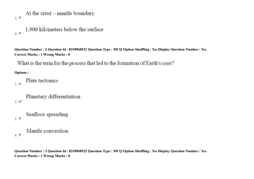
Question 1:
Where is Earth’s core located relative to the surface?
- (A) 2,900 kilometers below the surface
- (B) 3,900 kilometers below the surface
- (C) At the crust–mantle boundary
- (D) 1,900 kilometers below the surface
Question 2:
What is the term for the process that led to the formation of Earth's core?
- (A) Plate tectonics
- (B) Planetary differentiation
- (C) Seafloor spreading
- (D) Mantle convection
Question 3:
What are polymorphs in mineralogy?
- (A) Rocks formed under identical pressure and temperature conditions
- (B) Two or more minerals with the same chemical formula but different crystal structures
- (C) Crystals that form only in metamorphic environments
- (D) Minerals with different chemical formulas but similar crystal structures
Question 4:
What characterizes a porphyritic texture in igneous rocks?
- (A) Layers of alternating light and dark minerals
- (B) A texture in which some crystals are distinctly larger than the rest
- (C) Crystals that form only from volcanic eruptions
- (D) Uniformly sized crystals throughout the rock
Question 5:
Which of the following correctly describes the composition of Earth’s core?
- (A) Silicate rocks with low-density elements
- (B) Solid iron-nickel outer core and liquid silicate inner core
- (C) Liquid iron-nickel outer core and solid iron-nickel inner core
- (D) Primarily aluminum silicate with traces of magnesium
Question 6:
What is the process called when a parent rock transforms due to heat and pressure without melting?
- (A) Diagenesis
- (B) Metamorphism
- (C) Crystallization
- (D) Erosion
Question 7:
Which of the following best explains the term "continental shield"?
- (A) Submarine ridges with high heat flow
- (B) Oceanic crust covered by continental sediments
- (C) Large regions of exposed Precambrian crystalline igneous and metamorphic rocks
- (D) Young mountain ranges formed by recent tectonic activity
Question 8:
Which of the following is a framework silicate mineral?
- (A) Olivine
- (B) Biotite
- (C) Quartz
- (D) Pyroxene
Question 9:
The cleavage in mica minerals is described as:
- (A) Basal
- (B) Prismatic
- (C) Cubic
- (D) Irregular
Question 10:
The primary instrument used for measuring horizontal and vertical angles in surveying is:
- (A) Theodolite
- (B) Total station
- (C) Plane table
- (D) Dumpy level
Question 11:
High oblique photographs differ from low oblique photographs in that they:
- (A) Are taken from a higher altitude
- (B) Include the horizon in the image
- (C) Are taken with a vertical camera axis
- (D) Show less ground area
Question 12:
Which type of map projection assumes a globe resting on a flat surface, producing a circular map with a central point of tangency?
- (A) Conic Projection
- (B) Mercator Projection
- (C) Azimuthal Projection
- (D) Cylindrical Projection
Question 13:
Which map projection is widely used for nautical navigation due to its ability to represent lines of constant true direction?
- (A) Azimuthal Projection
- (B) Robinson Projection
- (C) Polyconic Projection
- (D) Mercator Projection
Question 14:
The point on the ground vertically beneath the camera at the time of exposure is called the:
- (A) Perceptive point
- (B) Nadir Point
- (C) Principal point
- (D) Isoline
Question 15:
Which of the following characteristics most clearly distinguishes an oblique photograph from a vertical photograph in aerial photography?
- (A) Uniform scale throughout the photograph
- (B) Ability to see the horizon in the photograph
- (C) Taken with the camera axis vertical to the ground
- (D) Presence of overlapping areas between photos
Question 16:
In remote sensing, super wide angle cameras are cameras whose angular field of view is:
- (A) Less than 60\(^\circ\)
- (B) Between 60\(^\circ\) and 90\(^\circ\)
- (C) Greater than 90\(^\circ\)
- (D) Exactly 180\(^\circ\)
Question 17:
What does the term 'radiance' refer to in radiometry?
- (A) Energy per unit wavelength
- (B) Energy per unit area
- (C) Energy per unit area per unit solid angle
- (D) Total energy emitted by a source
Question 18:
Which of the following is not a radiometric quantity?
- (A) Radiant flux
- (B) Irradiance
- (C) Reflectance
- (D) Radiance
Question 19:
Which orbit is best suited for continuous weather monitoring over a specific region?
- (A) Molniya orbit
- (B) Polar orbit
- (C) Geostationary orbit
- (D) Sun-synchronous orbit
Question 20:
Geostationary satellites orbit at approximately:
- (A) 35,786 km
- (B) 786 km
- (C) 1000 km
- (D) 500 km
Question 21:
Across-track stereoscopic imaging is typically obtained by:
- (A) Combining radar and optical data
- (B) Not combining radar and optical data
- (C) Using side-looking sensors from different satellite passes
- (D) Capturing nadir images over different regions
Question 22:
Which of the following satellite systems is capable of along-track stereo imaging using fore and aft sensors?
- (A) Cartosat-1
- (B) MODIS
- (C) SPOT
- (D) Landsat
Question 23:
Across-track stereoscopic imaging is typically obtained by:
- (A) Combining radar and optical data
- (B) Not combining radar and optical data
- (C) Using side-looking sensors from different satellite passes
- (D) Capturing nadir images over different regions
Question 24:
Which of the following satellite systems is capable of along-track stereo imaging using fore and aft sensors?
- (A) Cartosat-1
- (B) MODIS
- (C) SPOT
- (D) Landsat
Question 25:
Which among the following is not related to GIS software’s?
- (A) STAAD Pro
- (B) QGIS
- (C) ARCVIEW
- (D) CAD
Question 26:
Which of the following best describes topology in GIS?
- (A) Raster resolution accuracy
- (B) Geometric measurement of features
- (C) Spatial relationships between vector features
- (D) Storage of attribute information
Question 27:
Which GIS file format is most commonly used for storing vector data, including points, lines, and polygons?
- (A) .img
- (B) .txt
- (C) .pps
- (D) .shp
Question 28:
Which of the following represents the correct set of coordinate classification in GIS?
- (A) Geographic, spherical systems
- (B) Geographic, projected systems
- (C) Linear, geometric systems
- (D) Spherical, projected systems
Question 29:
In GIS, what is the purpose of indexing spatial data in a database?
- (A) To speed up data visualization
- (B) To improve spatial query performance
- (C) To store backup copies of data
- (D) To manage spatial relationships
Question 30:
What is the key advantage of Object-Oriented Database Models in GIS?
- (A) They only work with vector data
- (B) They are easier to use than relational databases
- (C) They store data in a flat, three Dimensional table
- (D) They allow for more complex data relationships and inheritance
Question 31:
What is the primary advantage of using a hierarchical database structure in GIS?
- (A) Improved spatial data analysis
- (B) Faster query response times
- (C) Handling of data
- (D) Clear parent-child relationships between data sets
Question 32:
Which of the following would be considered a non-spatial data analysis technique?
- (A) Raster data interpolation
- (B) Database queries using SQL
- (C) Buffer zone creation
- (D) Network analysis
Question 33:
In GIS, what is the primary purpose of using symbology?
- (A) To perform spatial queries
- (B) To represent spatial features visually with symbols
- (C) To convert raster to vector
- (D) To store spatial data efficiently
Question 34:
Which of the following types of visualizations would be most appropriate for displaying elevation data?
- (A) Heat map
- (B) Bar chart
- (C) 3D surface model
- (D) Line graph
Question 35:
......... map projection is best suited for regional or hemispheric maps, but unsuitable for entire world map.
- (A) Cylindrical
- (B) Equivalent
- (C) Conical
- (D) Azimuthal
Question 36:
Which attribute is not associated with digital maps?
- (A) Colour
- (B) Symbology
- (C) South arrow
- (D) Legends
Question 37:
Across track scanning systems are also called as _________ scanner systems.
- (A) Push broom
- (B) Lateral broom
- (C) Pull broom
- (D) Whisk broom
Question 38:
RISAT stands for _________.
- (A) Radio Satellite
- (B) Radio Navigation and Ranging Satellite
- (C) Radar Imaging Satellite
- (D) Reference system
Question 39:
Joint earth-observing mission between ISRO and NASA using advanced radar imaging system is known as ________.
- (A) NASA-ISRO Systematic Radar Mission (NISAR)
- (B) NASA-ISRO Synthetic Aperture Radar (NISAR)
- (C) NASA-ISRO Side-looking Aperture Radar (NISAR)
- (D) NASA-ISRO Side-looking Aperture Radio (NISAR)
Question 40:
Instrument used for monitoring water levels in rivers/reservoirs from space is known as ________.
- (A) Stadiometer or Satellite Stadiometer
- (B) Altimeter or Satellite Altimeter
- (C) Space Theodolite
- (D) LISS
Question 41:
________ resolution defines the smallest difference of radiant energy detected by a sensor.
- (1) Spectral resolution
- (2) Radiometric resolution
- (3) Temporal resolution
- (4) Spatial resolution
Question 42:
Diffused reflection of solar radiation from earth’s surface is known as __________.
- (1) Radiance
- (2) Irradiance
- (3) Albedo
- (4) Reflectance
Question 43:
The energy quantum for radiation is proportional to its __________.
- (1) Frequency
- (2) Reciprocal of energy
- (3) Square of frequency
- (4) Square root of frequency
Question 44:
Output from a thermal sensor is a measurement of ________ temperature of an object.
- (1) Kinetic
- (2) Radiant
- (3) Blackbody
- (4) Infrared
Question 45:
Who is known as father of Indian Space Program?
- (1) Prof. P. R. Pisharoty
- (2) Dr. Vikram Sarabhai
- (3) Dr. Homi J. Bhabha
- (4) Prof. U. R. Rao
Question 46:
National Remote Sensing Day is celebrated on ________ every year.
- (1) August 12
- (2) June 5
- (3) November 14
- (4) August 15
Question 47:
Which colour of EM spectrum is used for bathymetry studies?
- (1) Red
- (2) UV
- (3) SWIR
- (4) Green
Question 48:
Rayleigh scattering occurs when particle size is _____ than wavelength of incoming radiation.
- (1) very small
- (2) equal
- (3) not equal
- (4) very big
Question 49:
The reflectance ________ with presence of moisture, surface roughness or organic content in soils.
- (1) increases
- (2) decreases
- (3) remains same
- (4) zero
Question 50:
In digital image processing, the ________ process adjusts translational and rotational alignment between two images.
- (1) Registration
- (2) Filtering
- (3) Enhancement
- (4) Processing
Question 51:
________ helps to transform a correlated dataset into uncorrelated dataset.
- (1) Rationing
- (2) Principal Component Analysis
- (3) Fusion
- (4) Classification
Question 52:
Rectification accuracy is expressed in terms of ________ error.
- (1) Commission
- (2) Root Mean Square
- (3) Kappa
- (4) Omission
Question 53:
Spectral region of electromagnetic radiation which passes through atmosphere without much attenuation is known as _________.
- (1) Ozone hole
- (2) Atmospheric window
- (3) Ozone window
- (4) Black hole
Question 54:
GIS ideally deals with _________.
- (1) Numeric data
- (2) Binary data
- (3) Spatial data
- (4) Complex data
Question 55:
SDI stands for
- (1) Spatial Data Interface
- (2) Spatial Data Infrastructure
- (3) Spatial Data Intention
- (4) Spatial Data International
Question 56:
________ defines the property of connectivity in GIS.
- (1) Proximity
- (2) Neighbourhood
- (3) Topology
- (4) Boolean Identity
Question 57:
Which of the following are true of AM/FM systems?
- (1) The terms GIS and AM/FM are synonymous
- (2) AM/FM are always vector based
- (3) AM/FM is a specialized GIS
- (4) AM/FM systems are always confined to the utility industry
Question 58:
India-WRIS is a portal for ________.
- (1) Agricultural resources
- (2) Water resources
- (3) Forest resources
- (4) Geological resources
Question 59:
________ is a type of vector data model.
- (1) Spaghetti
- (2) Spatial
- (3) Raster
- (4) Quadtree
Question 60:
The purpose of GIS data models is to ________.
- (1) Generate random data structures
- (2) Analyse and describe fictional features in GIS
- (3) Represent real-world features in various forms like points, lines, arcs, and polygons
- (4) Create abstract sculptures of real world
Question 61:
________ function is performed by data input/capture subsystem of GIS.
- (1) Retrieval of data elements
- (2) Storage of data elements
- (3) Acquiring data
- (4) Transformation of data
Question 62:
A network is a series of interconnecting lines along which there is a flow of ________.
- (1) Entities
- (2) Points
- (3) Nodes
- (4) Data
Question 63:
Which interpolation technique is not used for continuous data?
- (1) Kriging
- (2) Trend surface fitting
- (3) Digitization
- (4) Triangulation
Question 64:
What is the approximate radius of the Earth?
- (1) 5,000 km
- (2) 6,371 km
- (3) 7,500 km
- (4) 8,000 km
Question 65:
The Earth’s core is primarily made up of which two elements?
- (1) Silicon and Oxygen
- (2) Iron and Nickel
- (3) Iron and Magnesium
- (4) Nickel and Oxygen
Question 66:
Which of the following statements accurately describes the formation of an intrusive igneous rock?
- (1) It forms from the rapid cooling of lava on the Earth's surface, resulting in fine-grained crystals.
- (2) It forms from the compaction and cementation of sediments over millions of years.
- (3) It forms from the slow cooling of magma beneath the Earth's surface, allowing for the development of large crystals.
- (4) It forms from the transformation of existing rocks due to high temperatures and pressures.
Question 67:
Which one of the following are the two main constituents of granite?
- (1) Iron and nickel
- (2) Iron and silver
- (3) Silica and aluminium
- (4) Iron Oxide and potassium
Question 68:
Which of the following rocks is an intrusive igneous rock?
- (1) Basalt
- (2) Rhyolite
- (3) Granite
- (4) Pumice
Question 69:
Which rock type primarily forms from cooling of lava on Earth's surface?
- (1) Plutonic igneous
- (2) Volcanic igneous
- (3) Metamorphic
- (4) Clastic sedimentary
Question 70:
Which of the following is true about rocks?
- (1) Rocks are composed of only one mineral.
- (2) Rocks do not contain any non-mineral matter.
- (3) Coal is not considered a true rock.
- (4) Most rocks are a mixture of minerals.
Question 71:
A rock that forms from cooling lava is classified as an:
- (1) Intrusive igneous rock
- (2) Extrusive igneous rock
- (3) Extrusive metamorphic rock
- (4) Intrusive volcanic rock
Question 72:
Which environment is most favourable for the formation of metamorphic rocks?
- (1) High pressure and high temperature
- (2) Low pressure and low temperature
- (3) High pressure and low temperature
- (4) Surface weathering
Question 73:
Igneous rocks that crystallize from magma and are composed almost entirely of quartz and feldspars have a _________.
- (1) Granitic composition
- (2) Ultramafic composition
- (3) Andesitic composition
- (4) Basaltic composition
Question 74:
The mineral group that constitutes most of Earth's crust is _____.
- (1) Carbonates
- (2) Oxides
- (3) Silicates
- (4) Sulfides
Question 75:
Which of the following statements accurately distinguishes between a silicate and a non-silicate mineral?
- (1) Silicate minerals are always harder than non-silicate minerals.
- (2) Non-silicate minerals never contain oxygen in their chemical formula.
- (3) Silicate minerals contain silicon and oxygen as major elements, while non-silicate minerals do not always contain both.
- (4) Non-silicate minerals are always formed through biological processes.
Question 76:
Which instrument is primarily used to measure angles between lines of sight in surveying?
- (1) A GPS receiver.
- (2) A theodolite.
- (3) A level.
- (4) A clinometer.
Question 77:
Which type of aerial photograph is taken with the camera's optical axis directed vertically downward?
- (1) An oblique photograph.
- (2) A tilted photograph.
- (3) A stereoscopic photograph.
- (4) A vertical photograph.
Question 78:
Which of the following is NOT typically found as marginal information on a topographic sheet?
- (1) The sheet name and number.
- (2) The contour interval.
- (3) The magnetic declination.
- (4) The coordinates of specific landmarks within the mapped area.
Question 79:
Parallax in aerial photographs is an error due to \hspace{2cm}.
- (1) Movement of camera and ground relief
- (2) Overlap in photographs
- (3) Distortion caused by camera lens
- (4) Distortion due to lack of focus
Question 80:
In map projections, the Mercator projection is best suited for \hspace{2cm}.
- (1) Polar regions
- (2) Small-scale world maps
- (3) Navigation purposes
- (4) Land use planning
Question 81:
Which of the following is a key characteristic of a map projection?
- (1) It accurately portrays the true shape of the Earth's surface.
- (2) It preserves the scale and area of the map.
- (3) It provides a 3D representation of the terrain.
- (4) It distorts the Earth's shape to fit on a flat surface.
Question 82:
Which aerial photo format typically provides the largest area of coverage on a single photograph?
- (1) Small format (e.g., 70mm)
- (2) Medium format (e.g., 9 inches × 9 inches)
- (3) Large format (e.g., 12 inches × 12 inches)
- (4) Digital imagery with a small sensor size.
Question 83:
Which type of map projection is most likely to distort the shape of large landmasses?
- (1) Cylindrical map projection.
- (2) Conic map projection.
- (3) Planar map projection.
- (4) Gnomonic map projection.
Question 84:
The process of transforming and representing features from the Earth's curved surface onto a flat map is known as \hspace{1.5cm}.
- (1) Geo-referencing.
- (2) Cartography.
- (3) Photogrammetry.
- (4) Remote sensing.
Question 85:
In cartography, map generalization refers to the process of:
- (1) Accurately representing every single feature on the ground at the map scale.
- (2) Simplifying or omitting features on a map to maintain clarity and legibility at a reduced scale.
- (3) Projecting geographic coordinates onto a flat map surface.
- (4) Assigning colors and symbols to different features on a map.
Question 86:
The propagation of electromagnetic waves involves the interplay of oscillating:
- (1) Electric and magnetic fields perpendicular to each other and the direction of propagation.
- (2) Electric and gravitational fields parallel to each other and perpendicular to the direction of propagation.
- (3) Magnetic and gravitational fields perpendicular to each other and parallel to the direction of propagation.
- (4) Electric and magnetic fields parallel to each other and the direction of propagation.
Question 87:
Radiance is best defined as:
- (1) Power per unit area
- (2) Power per unit solid angle
- (3) Power per unit area per unit solid angle
- (4) Power per unit wavelength
Question 88:
Which of the following defines the spatial resolution of a sensor?
- (1) Number of spectral bands
- (2) Smallest object detectable on the ground
- (3) Energy detection capacity
- (4) Frequency of satellite revisits
Question 89:
Higher radiometric resolution means:
- (1) Ability to distinguish finer wavelength differences
- (2) Ability to detect small differences in energy
- (3) Ability to capture more images per day
- (4) Ability to detect larger objects
Question 90:
Along-track stereoscopic imaging involves __________.
- (1) Two separate satellites imaging the same area
- (2) Imaging the same area from different angles during the same orbit
- (3) Successive orbits imaging the same area
- (4) Using a microwave radar for 3D imaging
Question 91:
Which systematic error in digital image processing is caused by the Earth's rotation during image acquisition?
- (1) Scan Skew
- (2) Mirror-Scan Velocity
- (3) Panoramic Distortion
- (4) Earth Rotation
Question 92:
The ALOS satellite belongs to ________.
- (1) Europe
- (2) Japan
- (3) Canada
- (4) India
Question 93:
The Copernicus program for Earth Observation is run by ________.
- (1) NASA
- (2) JAXA
- (3) ESA - European Space Agency
- (4) ISRO
Question 94:
Which image enhancement technique stretches the range of pixel intensity values to cover the full dynamic range of display devices?
- (1) Level slicing
- (2) Contrast stretching
- (3) Gray level thresholding
- (4) Histogram equalization
Question 95:
The European Space Agency's primary Earth observation program is known as _______.
- (1) ENVISAT/Sentinel
- (2) JERS
- (3) ALOS
- (4) CBERS
Question 96:
For urban mapping requiring very detailed building footprints, the ideal satellite would provide _______.
- (1) 30 m spatial resolution multispectral data
- (2) 5 m spatial resolution panchromatic data
- (3) 1 m or finer spatial resolution imagery
- (4) 250 m spatial resolution MODIS data
Question 97:
What does spectral resolution refer to in remote sensing?
- (1) Ability to detect different wavelengths of electromagnetic radiation
- (2) Ability to distinguish between different features on the ground
- (3) Ability to capture images at various times
- (4) Ability to discern details within an image
Question 98:
Which of the following best describes a relational database structure commonly used in GIS?
- (1) Data is organized in a tree-like hierarchy.
- (2) Data elements are linked through predefined relationships, forming a network.
- (3) Data is organized into tables with rows representing entities and columns representing attributes, with relationships established through keys.
- (4) Spatial data and attribute data are stored in separate, unconnected files.
Question 99:
Raster data typically represents geographic phenomena as:
- (1) Points, lines, and polygons.
- (2) A grid of cells, each with an associated value.
- (3) Topologically structured features with nodes and edges.
- (4) A collection of attribute records linked to spatial coordinates.
Question 100:
A topological error where adjacent polygons overlap is called ________.
- (1) Dangle
- (2) Overshoot
- (3) Gap
- (4) Sliver
Question 101:
DEM files are critical in which GIS applications?
- (1) Noise pollution mapping
- (2) Surface water runoff modeling
- (3) Soil pH mapping
- (4) Land use categorization
Question 102:
In raster to vector conversion, errors typically occur because of ______.
- (1) Topological inaccuracies
- (2) Attribute duplication
- (3) File compression
- (4) Metadata loss
Question 103:
In the vector data model, an area is typically stored as ______.
- (1) A single coordinate pair representing its centroid.
- (2) A grid of cells covering its extent.
- (3) A closed sequence of connected coordinate pairs forming a polygon.
- (4) A series of disconnected line segments
Question 104:
TIN (Triangulated Irregular Network) sheeting is a method used to represent ______.
- (1) Categorical spatial data.
- (2) Continuous surface data using non-overlapping triangles.
- (3) Linear features with associated attributes.
- (4) Regularly spaced grid data
Question 105:
A common challenge in raster to vector conversion, especially when dealing with scanned maps, is ______.
- (1) Loss of attribute information.
- (2) Introduction of topological errors.
- (3) Generalization and loss of detail in curved or complex features.
- (4) Difficulty in assigning coordinate values.
Question 106:
Structured Query Language (SQL) is primarily used in GIS to ______.
- (1) Perform spatial analysis operations.
- (2) Manage and query attribute data stored in databases.
- (3) Visualize spatial data in different map projections.
- (4) Convert data between different file formats.
Question 107:
A GPS collected point dataset suffers from high horizontal error.
The best immediate action is:
- (1) Increase the sampling interval
- (2) Correct using differential GPS (DGPS)
- (3) Rasterize the point data
- (4) Smooth using TIN creation
Question 108:
In the context of GIS modeling, a conceptual model represents:
- (1) The physical implementation of the database.
- (2) A high-level, user-oriented understanding of the real-world phenomena and their relationships.
- (3) The logical organization of data elements and their relationships within a database.
- (4) The specific data structures and file formats used to store the data.
Question 109:
A key characteristic of object-oriented database models in GIS is their ability to:
- (1) Only store spatial data efficiently.
- (2) Represent both spatial and non-spatial data as objects with associated attributes and behaviors (methods).
- (3) Organize data in a strictly hierarchical structure.
- (4) Primarily handle raster data.
Question 110:
Recent trends in GIS applications include all EXCEPT:
- (1) Mobile GIS
- (2) Cloud-based GIS
- (3) Real-time spatial analytics
- (4) Paper-based cartography
Question 111:
In GIS, what is the function of a topology rule?
- (1) To enforce spatial relationships between features
- (2) To define the spatial extent of a dataset
- (3) To specify the coordinate system of a map
- (4) To categorize features based on attributes
Question 112:
In the context of hydrological modeling within GIS, a Digital Elevation Model (DEM) is crucial for:
- (1) Determining soil texture and permeability.
- (2) Estimating evapotranspiration rates.
- (3) Delineating watersheds and analyzing flow direction.
- (4) Measuring rainfall intensity directly.
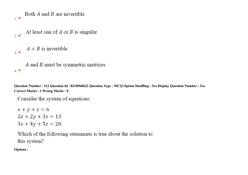
Question 113:
If \( A \) and \( B \) are two non-zero square matrices of same size such that the product matrix \( AB \) is a zero matrix, then which of the following must be true?
- (1) Both \( A \) and \( B \) are invertible
- (2) At least one of \( A \) or \( B \) is singular
- (3) \( A + B \) is invertible
- (4) \( A \) and \( B \) must be symmetric matrices
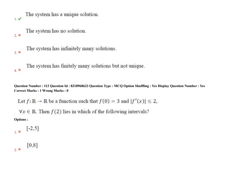
Question 114:
Consider the system of equations: \[ \begin{aligned} x + y + z &= 6
2x + 2y + 3z &= 13
3x + 4y + 5z &= 20 \end{aligned} \]
Which of the following statements is true about the solution to this system?
- (1) The system has a unique solution.
- (2) The system has no solution.
- (3) The system has infinitely many solutions.
- (4) The system has finitely many solutions but not unique.
Question 115:
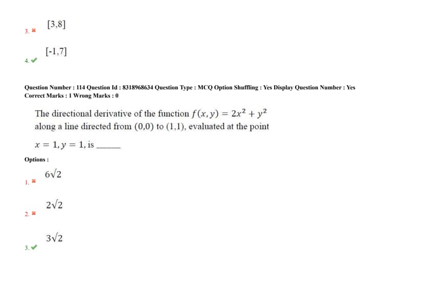
Let \( f: \mathbb{R} \rightarrow \mathbb{R} \) be a function such that \( f(0) = 3 \) and \( |f'(x)| \leq 2 \), \( \forall x \in \mathbb{R} \). Then \( f(2) \) lies in which of the following intervals?
- (1) \([-2, 5]\)
- (2) \([0, 8]\)
- (3) \([3, 8]\)
- (4) \([-1, 7]\)
Question 116:
The directional derivative of the function \( f(x, y) = 2x^2 + y^2 \)
along a line directed from \( (0, 0) \) to \( (1, 1) \), evaluated at the point \( x = 1, y = 1 \), is \underline{\hspace{2cm
- (1) \( 6\sqrt{2} \)
- (2) \( 2\sqrt{2} \)
- (3) \( 3\sqrt{2} \)
- (4) \( 6 \)
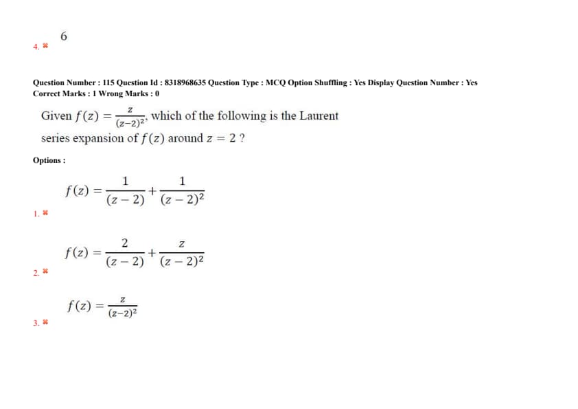
Question 117:
Given \( f(z) = \dfrac{-z}{(z - 2)^2} \), which of the following is the Laurent series expansion of \( f(z) \) around \( z = 2 \)?
- (1) \( f(z) = \dfrac{1}{(z - 2)} + \dfrac{1}{(z - 2)^2} \)
- (2) \( f(z) = \dfrac{2}{(z - 2)} + \dfrac{z}{(z - 2)^2} \)
- (3) \( f(z) = \dfrac{z}{(z - 2)^2} \)
- (4) \( f(z) = \dfrac{1}{(z - 2)} + \dfrac{2}{(z - 2)^2} \)
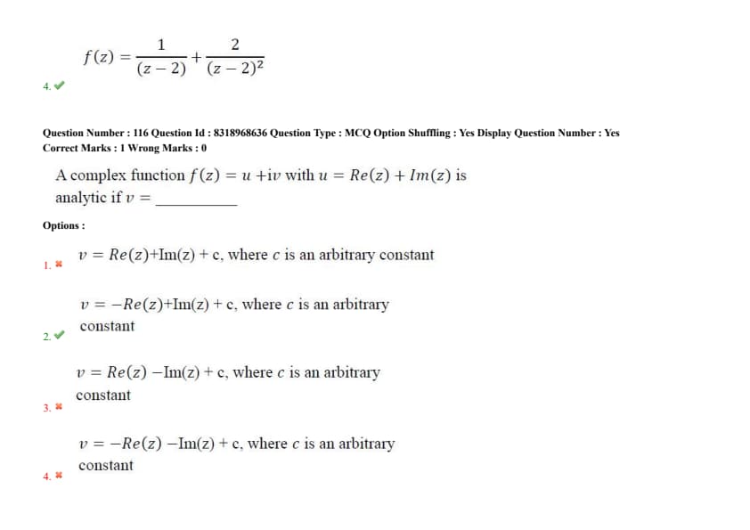
Question 118:
A complex function \( f(z) = u + iv \) with \( u = \operatorname{Re}(z) + \operatorname{Im}(z) \) is analytic if \( v = \) ________
- (1) \( v = \operatorname{Re}(z) + \operatorname{Im}(z) + c \), where \( c \) is an arbitrary constant
- (2) \( v = -\operatorname{Re}(z) + \operatorname{Im}(z) + c \), where \( c \) is an arbitrary constant
- (3) \( v = \operatorname{Re}(z) - \operatorname{Im}(z) + c \), where \( c \) is an arbitrary constant
- (4) \( v = -\operatorname{Re}(z) - \operatorname{Im}(z) + c \), where \( c \) is an arbitrary constant
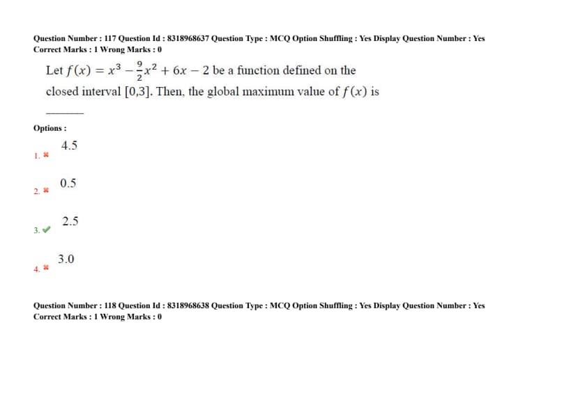
Question 119:
Let \( f(x) = x^3 - \dfrac{9}{2}x^2 + 6x - 2 \) be a function defined on the closed interval \( [0, 3] \). Then, the global maximum value of \( f(x) \) is
- (1) 4.5
- (2) 0.5
- (3) 2.5
- (4) 3.0
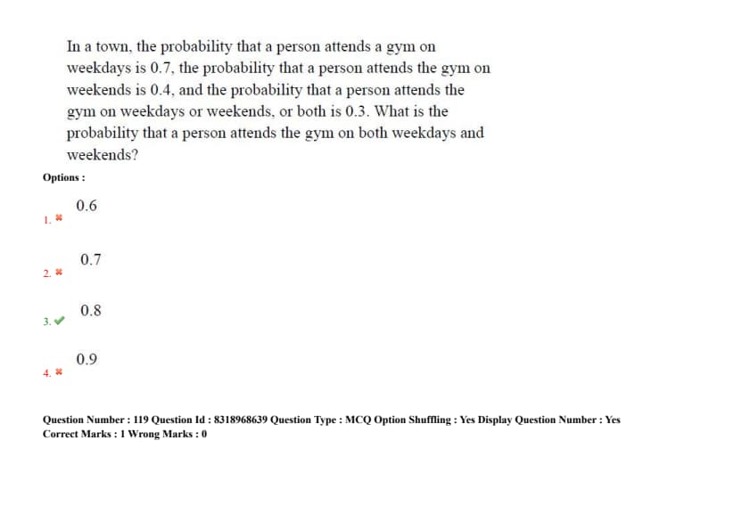
Question 120:
In a town, the probability that a person attends a gym on weekdays is 0.7, the probability that a person attends the gym on weekends is 0.4, and the probability that a person attends the gym on weekdays or weekends, or both is 0.3. What is the probability that a person attends the gym on both weekdays and weekends?
- (1) 0.6
- (2) 0.7
- (3) 0.8
- (4) 0.9
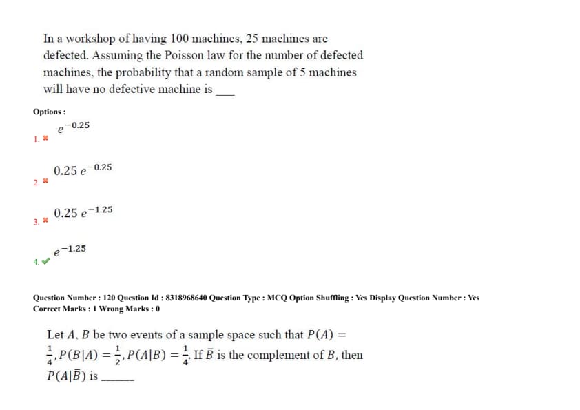
Question 121:
In a workshop of 100 machines, 25 machines are defective. Assuming the Poisson law for the number of defective machines, the probability that a random sample of 5 machines will have no defective machine is
- (1) \( e^{-0.25} \)
- (2) \( 0.25\, e^{-0.25} \)
- (3) \( 0.25\, e^{-1.25} \)
- (4) \( e^{-1.25} \)
Question 122:
Let \( A, B \) be two events of a sample space such that \( P(A) = \frac{1}{4} \), \( P(B|A) = \frac{1}{2} \), \( P(A|B) = \frac{1}{4} \). If \( \overline{B} \) is the complement of \( B \), then \( P(A | \overline{B}) \) is _____
- (1) \( \dfrac{3}{4} \)
- (2) \( \dfrac{1}{4} \)
- (3) \( \dfrac{1}{3} \)
- (4) \( \dfrac{2}{3} \)


Comments