


TS PGECET 2023 Geo Engineering and Geo Informatics Question Paper with Answer key PDF is available here for download. TS PGECET 2023 was conducted by JNTU Hyderabad on behalf of TSCHE on May 29, 2023. TS PGECET 2023 GG Question Paper consisted of 120 questions carrying 1 mark for each.
TS PGECET 2023 Geo Engineering and Geo Informatics Question Paper
| TS PGECET 2023 GG Question Paper with Answer Key | Download PDF | Check Solution |

Question 1:
Let A be a square matrix of order 4 with \(|A| = 6\). Then \(|2A| = \)
View Solution
We are given that \(|A| = 6\) for a 4x4 matrix \(A\). When multiplying a square matrix \(A\) by a scalar \(k\), the determinant of the new matrix \(kA\) is given by: \[ |kA| = k^n \cdot |A| \]
where \(n\) is the order of the matrix. For \(A\) with order 4, the formula becomes: \[ |2A| = 2^4 \cdot |A| = 16 \cdot 6 = 96 \]
Thus, \(|2A| = 96\).
Quick Tip: When dealing with scalar multiplication of matrices, remember that the determinant of a matrix scales by the scalar raised to the power of the matrix order.
The number of solutions of the system of equations \(x - y + 3z = 3\), \(2x + 3y + z = 2\), and \(3x + 2y + 4z = 5\) is
View Solution
The system of equations can be solved using Gaussian elimination or substitution methods. After performing the necessary steps, we find that the system has infinite solutions, as the system is consistent and dependent.
Quick Tip: When solving linear systems, always check for consistency by evaluating the rank of the augmented matrix. If the rank of the coefficient matrix is less than the rank of the augmented matrix, no solution exists.
If the sum of the eigenvalues of the matrix \(\begin{pmatrix} 1 & 3 & 5
2 & k & 3
4 & -1 & 5 \end{pmatrix}\) is 15, then \(k =\)
View Solution
The sum of the eigenvalues of a matrix is equal to the trace of the matrix (the sum of the diagonal elements). Thus, for this matrix, the trace is \(1 + k + 5 = 6 + k\). We are given that the sum of the eigenvalues is 15, so: \[ 6 + k = 15 \]
Solving for \(k\), we get \(k = 9\).
Quick Tip: The trace of a matrix is the sum of its diagonal elements. This is a key property when calculating the sum of eigenvalues.
Find the limit \(\lim\limits_{x \to \infty} \frac{nx - n}{x^2 - 1}\)
View Solution
To evaluate the limit, first factor out \(x\) from both the numerator and denominator: \[ \lim\limits_{x \to \infty} \frac{nx - n}{x^2 - 1} = \lim\limits_{x \to \infty} \frac{n(x - 1)}{x(x^2 - 1)} \]
As \(x \to \infty\), the dominant terms are \(nx\) and \(x^2\), so the limit simplifies to: \[ \frac{n}{x} \to 1 \]
Thus, the limit is \(1\).
Quick Tip: For limits involving large values of \(x\), focus on the highest degree terms in both the numerator and denominator.
The improper integral \(\int_0^\infty \frac{dx}{\sqrt{x}}\) converges to
View Solution
To evaluate the improper integral, we consider the following: \[ \int_0^\infty \frac{dx}{\sqrt{x}} = \lim\limits_{b \to \infty} \int_0^b x^{-\frac{1}{2}} dx \]
The integral of \(x^{-\frac{1}{2}}\) is \(2x^{\frac{1}{2}}\), so: \[ \lim\limits_{b \to \infty} 2 \left[ x^{\frac{1}{2}} \right]_0^b = 2 \times (\infty^{\frac{1}{2}} - 0^{\frac{1}{2}}) = 2 \]
Thus, the integral converges to 2.
Quick Tip: When dealing with improper integrals, always ensure the integrand is well-behaved at the limits, and consider the limits separately.
The directional derivative of \(f(x, y) = xy(x^2 + y^2)\) at \((2,1)\) in the direction of the unit vector making an angle of \(\frac{\pi}{3}\) with the x-axis is
View Solution
The directional derivative is given by: \[ D_{\mathbf{u}}f = \nabla f \cdot \mathbf{u} \]
First, find the gradient of \(f(x, y)\): \[ \nabla f = \left( \frac{\partial f}{\partial x}, \frac{\partial f}{\partial y} \right) = \left( y(3x^2 + y^2), x(3y^2 + x^2) \right) \]
At the point \((2, 1)\), \(\nabla f = (14, 11)\). The unit vector in the direction of \(\frac{\pi}{3}\) is \(\mathbf{u} = (\cos\frac{\pi}{3}, \sin\frac{\pi}{3}) = \left(\frac{1}{2}, \frac{\sqrt{3}}{2}\right)\). Then: \[ D_{\mathbf{u}}f = (14, 11) \cdot \left(\frac{1}{2}, \frac{\sqrt{3}}{2}\right) = \frac{14}{2} + \frac{11\sqrt{3}}{2} = \frac{5 + 14\sqrt{3}}{2} \]
Thus, the directional derivative is \(\frac{5 + 14\sqrt{3}}{2}\).
Quick Tip: When finding the directional derivative, first compute the gradient and then take the dot product with the unit vector in the given direction.
The values of \(a\) and \(b\) so that the function \(f(z) = x - 2ay + i(x - by)\) is analytic are respectively
View Solution
For the function to be analytic, the Cauchy-Riemann equations must hold. From the real and imaginary parts of the function, we get two equations that lead to the values of \(a\) and \(b\). Solving these gives \(a = \frac{1}{2}\) and \(b = -1\).
Quick Tip: When dealing with analytic functions, always check the Cauchy-Riemann equations to find relationships between the constants.
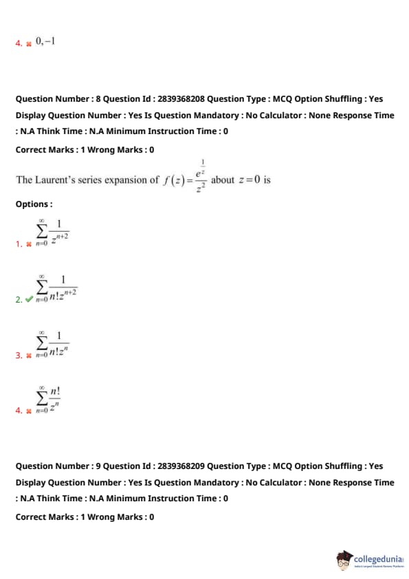
The Laurent's series expansion of \(f(z) = \frac{1}{z^2}\) about \(z = 0\) is
View Solution
The Laurent series expansion of \(\frac{1}{z^2}\) about \(z = 0\) contains only negative powers of \(z\). Hence, the series is \(\sum\limits_{n=1}^{\infty} z^{-n}\).
Quick Tip: In the Laurent series, negative powers of \(z\) are used to represent singularities or poles of a function.
Let \(A\) and \(B\) be two events such that \(P(A) = \frac{1}{2}\), \(P(B) = \frac{1}{3}\), and \(P(A \cap B) = \frac{1}{4}\). Then \(P(B | A) = \)
View Solution
By the definition of conditional probability, we have: \[ P(B | A) = \frac{P(A \cap B)}{P(A)} = \frac{\frac{1}{4}}{\frac{1}{2}} = \frac{2}{3} \]
Thus, \(P(B | A) = \frac{2}{3}\).
Quick Tip: To calculate conditional probability, divide the probability of the intersection by the probability of the given event.
A continuous random variable \(X\) has the p.d.f. \(f(x) = \frac{1}{k}\) for \(a \leq x \leq b\) and \(0\) elsewhere. The value of \(k\) is
View Solution
The probability density function (p.d.f.) must integrate to 1 over the entire range. Therefore, we have: \[ \int_a^b f(x) dx = 1 \quad \Rightarrow \quad \int_a^b \frac{1}{k} dx = 1 \]
This gives \(\frac{1}{k}(b - a) = 1\), and hence \(k = \frac{1}{b - a}\).
Quick Tip: The constant \(k\) in a uniform distribution is determined by ensuring that the total probability integrates to 1.
The flatter region beyond the reach of high tides is known as
View Solution
The berm is the flatter region on the shore, located beyond the reach of the high tide. It is often found on the beach and is an important feature in coastal morphology.
Quick Tip: Focus on understanding coastal features like berms, swash zones, and surf zones, which are important in coastal dynamics.
The formation where the longshore current slows and sediments accumulate is called as
View Solution
A tombolo is formed when a longshore current slows and sediments accumulate, creating a connection between the mainland and an island or other landforms. This formation is significant in coastal geomorphology.
Quick Tip: When studying coastal landforms, identify features that are formed by deposition and those created by erosion.
The valley formation, one which has steep step-like side slopes is called
View Solution
A canyon is a deep, steep-sided valley formed by the erosion of rivers. The steep side slopes are a key characteristic of this type of formation.
Quick Tip: Canyons and gorges are often formed in areas with intense erosion, resulting in steep, rugged landscapes.
If the series of smaller sinkholes come together to form a compound sinkhole is called as
View Solution
An uvala is formed when several smaller sinkholes come together to create a larger, compound sinkhole. It is a common feature in karst landscapes.
Quick Tip: In karst topography, sinkholes and uvalas are common features resulting from dissolution processes in limestone regions.
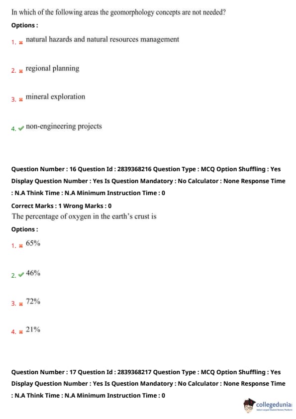
In which of the following areas the geomorphology concepts are not needed?
View Solution
Geomorphology plays an essential role in the study and management of natural hazards, resources, and even in mining operations. However, non-engineering projects may not require detailed geomorphological analysis.
Quick Tip: Geomorphology is essential in fields related to land use and resource management but may be less relevant to non-engineering disciplines.
The percentage of oxygen in the Earth's crust is
View Solution
Oxygen makes up approximately 46% of the Earth's crust by weight. It is the most abundant element in the crust, combined with other elements like silicon.
Quick Tip: Remember that oxygen is the most abundant element in the Earth's crust and plays a key role in the formation of silicate minerals.
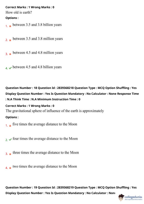
How old is earth?
View Solution
The Earth is approximately 4.5 billion years old, based on radiometric dating of rocks and minerals. This is the generally accepted age of the Earth.
Quick Tip: Radiometric dating using isotopic decay is the key method for determining the age of the Earth and other celestial bodies.
The gravitational sphere of influence of the earth is approximately
View Solution
The sphere of influence of a celestial body refers to the region where its gravitational pull dominates over the gravitational influence of other bodies. The Earth's sphere of influence is approximately three times the average distance to the Moon.
Quick Tip: This concept is important when studying orbital mechanics, as it defines the region where the Earth's gravity is the dominant force.
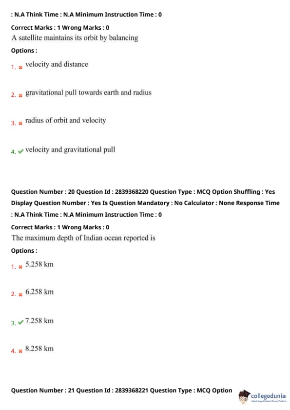
A satellite maintains its orbit by balancing
View Solution
A satellite stays in orbit due to the balance between the gravitational pull from the Earth and its orbital velocity. If either the velocity or the gravitational pull changes, the satellite will either fall back to Earth or fly off into space.
Quick Tip: Understanding the relationship between velocity and gravitational pull is key to understanding satellite motion.
The maximum depth of the Indian Ocean reported is
View Solution
The maximum depth of the Indian Ocean is approximately 5.258 km, which is recorded at the Java Trench.
Quick Tip: Remember that the oceans have varying depths, with trenches being the deepest areas.
The gradient of the continental slope varies between
View Solution
The continental slope typically has a gradient of about 2° to 5°. This is the steep region that separates the continental shelf from the deep ocean floor.
Quick Tip: The continental slope is an important feature in understanding the transition from continental crust to oceanic crust.
The shallowest part of the ocean which has an average gradient of 1° or even less is called as
View Solution
The continental shelf is the shallowest part of the ocean with a very gentle slope, typically less than 1° in gradient. It is rich in marine life and important for fishing and resource extraction.
Quick Tip: Continental shelves are often used for marine resource exploration due to their shallow nature and access to various biological and mineral resources.
The Mohr's hardness value of Feldspar ranges between
View Solution
Feldspar, a common group of minerals in the Earth's crust, has a hardness of 6 to 6.5 on the Mohs scale. This makes it a moderately hard mineral.
Quick Tip: The Mohs hardness scale is used to measure the hardness of minerals, with Feldspar being classified as moderately hard.
Which of the following is correct as per the uses of corundum mineral is concerned
View Solution
Corundum is a very hard mineral used primarily in optical and space equipment due to its hardness and stability. It is also the mineral form of sapphires and rubies.
Quick Tip: Corundum’s hardness makes it ideal for use in applications where durability and scratch resistance are required, such as in precision instruments.
Number of tetrahedrons needed to build even a small crystal are
View Solution
Crystals are made of a large number of tetrahedrons that are arranged in a specific structure. Even a small crystal requires thousands of these units.
Quick Tip: In crystallography, understanding the structure and arrangement of tetrahedrons is key to determining the properties of the crystal.
If \(P\) = precipitation, \(ET\) = evapotranspiration, \(G\) = percolation loss to ground water, \(Q\) = direct runoff and \(\Delta S\) = change in soil moisture storage then, the equation for water balance is
View Solution
The water balance equation represents the inflow and outflow of water in a system. The correct equation is: \[ P = ET + G + Q + \Delta S \]
where \(P\) is the precipitation, \(ET\) is the evapotranspiration, \(G\) is the percolation loss, \(Q\) is the direct runoff, and \(\Delta S\) is the change in soil moisture storage.
Quick Tip: Water balance equations are crucial in hydrology to understand how water flows through different parts of a system.
The energy needed to change the state of the molecules of water from liquid to vapor in the evapotranspiration process is obtained from
View Solution
The energy required for evapotranspiration is primarily provided by high solar radiation, which heats the water molecules and causes them to transition from liquid to vapor.
Quick Tip: Evapotranspiration is a key process in the water cycle, driven by solar energy and influenced by both temperature and humidity.
At the surface of the water table, the water pressure head is equal to
View Solution
At the surface of the water table, the pressure head is approximately 100 kPa, which corresponds to the pressure exerted by the water column above it.
Quick Tip: Water pressure head is an important factor in hydrogeology as it determines the movement of groundwater in the subsurface.
Which is the incorrect one among the following as per the expertise of environmental geologist is concerned
View Solution
Environmental geologists focus on ecosystems like wetlands, streams, rivers, and shorelines. Protection and repair of building structures founded on subsurface soil is typically outside their scope of expertise.
Quick Tip: Environmental geologists play a crucial role in protecting ecosystems, but they typically do not focus on structural engineering concerns.
The thickness of the troposphere is
View Solution
The troposphere is the lowest layer of Earth's atmosphere, and its average thickness is around 10 km. It contains most of the Earth's weather phenomena.
Quick Tip: The troposphere is essential for weather patterns and life, as it contains the majority of the atmosphere's mass and water vapor.
Which of the following environmental components provides the basis for biotic factors?
View Solution
The biosphere provides the basis for biotic factors as it is the global sum of all ecosystems, and it includes all living organisms and their interactions.
Quick Tip: Biotic factors refer to living organisms and their relationships, which are mainly influenced by the biosphere.
The subject that studies complex interaction of human with nature and provides guidelines for the way forward is called
View Solution
Environmental science is the interdisciplinary study that focuses on the interaction between humans and nature, and it provides strategies for sustainable development.
Quick Tip: Environmental science combines knowledge from various fields like biology, chemistry, and ecology to address environmental challenges.
Which of the following soils have high shear strength
View Solution
Soils with a higher density index, such as 75%, have better compaction and higher shear strength. This is important in construction and civil engineering projects.
Quick Tip: High density index soils are typically more stable and resistant to shear stress, making them ideal for building foundations.
If a soil has porosity of 0.5 and discharge velocity of \(1 \times 10^{-4}\) cm/s, then its seepage velocity is
View Solution
The seepage velocity can be calculated by multiplying the discharge velocity by the inverse of the porosity: \[ Seepage velocity = \frac{Discharge velocity}{Porosity} = \frac{1 \times 10^{-4} \, cm/s}{0.5} = 2 \times 10^{-4} \, cm/s \]
Thus, the seepage velocity is \(2 \times 10^{-4}\) cm/s.
Quick Tip: Seepage velocity is important in hydrology as it determines the rate at which groundwater moves through porous media.
The ideal soil texture consists of
View Solution
The ideal soil texture is a balanced mix of sand, silt, and clay particles, which allows for good water retention and drainage while providing necessary nutrients for plant growth.
Quick Tip: Ideal soil texture supports optimal plant growth by balancing water retention and drainage.
An exposure of younger strata that are completely surrounded by older strata is called
View Solution
An outlier is a geological feature where younger strata are surrounded by older strata, often due to erosion or other geological processes.
Quick Tip: Outliers are important in the study of geological formations, helping to understand the relative age of rocks.
The units above and below the unconformity surface are parallel to each other, but not continuous in deposition are called as
View Solution
Angular unconformities occur when layers of rock are tilted and then eroded before newer layers are deposited on top. This creates a discontinuity between the older and younger layers.
Quick Tip: Angular unconformities are a key indicator of past geological events, such as tectonic forces and erosion.
The deformation, a rock can undergo when subjected to stress at certain depths within the earth, where pressures and temperatures are high is called
View Solution
Ductile deformation occurs when rocks are subjected to high temperatures and pressures deep within the Earth. This allows the rock to bend and flow, rather than fracture.
Quick Tip: Ductile deformation is key in the formation of folds and mountain ranges under high pressure and temperature conditions.
Those folds which are having an interlimb angle more than 70° are called as
View Solution
Folds with an interlimb angle greater than 70° are called open folds. They are less compressed and have a wider angle between the limbs.
Quick Tip: Open folds are characteristic of regions where the compressive forces are not as intense, allowing for larger angles between fold limbs.
The joints which form when the rocks expand as a result of the rapid removal of the overlying rock cover are called
View Solution
Sheet joints are formed when the Earth's surface erodes, removing the weight from overlying rock, which causes the rock to expand and form joints. These are common in granite and other igneous rocks.
Quick Tip: Sheet joints are important in understanding the weathering processes of rocks, particularly in mountainous regions.
The rocks with a strong secondary planar fabric are known as
View Solution
LS-tectonites are rocks that exhibit strong secondary planar fabric due to deformation, often showing evidence of shearing and foliation. These fabrics form under high-pressure conditions.
Quick Tip: LS-tectonites are often associated with regions of intense tectonic stress where the rocks undergo significant deformation.
Which portion of the spherical projection, a geologist will use for crystallographic analysis?
View Solution
Geologists typically use the entire spherical projection for crystallographic analysis to examine the orientation of crystal faces and planes in three-dimensional space.
Quick Tip: The whole spherical projection helps in understanding crystal symmetry and the orientation of crystal axes.
Tectonites which allows the rock to split into rod-like shapes due to the two intersecting planes are called
View Solution
L-tectonites form when a rock is subjected to two intersecting planes of stress, allowing it to split into rod-like shapes. This is characteristic of rocks that have undergone shearing deformation.
Quick Tip: L-tectonites are associated with high shear stresses that cause rocks to fracture along preferred planes.
The rocks which contain reasonable amounts of dynamically crystallized fine-grained material are called
View Solution
Mylonitic rocks are a type of metamorphic rock formed under high shear stress, containing fine-grained material that crystallizes dynamically. These rocks are typically formed in shear zones.
Quick Tip: Mylonitic rocks are characterized by their fine-grained texture, resulting from intense deformation and recrystallization.
The combination of strike-slip and dip-slip falls under which type of shear zones?
View Solution
Oblique-slip shear zones involve both strike-slip and dip-slip motion, where lateral and vertical displacements occur simultaneously due to the applied stress.
Quick Tip: Oblique-slip faults combine both horizontal and vertical movement, making them crucial for understanding tectonic processes.
The shielded areas, which help shielding the matrix on the flanks of the inclusion from strain is called
View Solution
Pressure shadows are formed around inclusions in deformed rocks, where the inclusion provides resistance to the surrounding strain, thus creating a shielded region.
Quick Tip: Pressure shadows are common in high-strain zones and indicate areas where rocks are subjected to differential stress.
Twining in crystals occur when two different types of crystals share the same crystal lattice points in a
View Solution
In crystallography, twinning occurs when two crystal lattices share some of their lattice points, and the twin boundaries are symmetrical.
Quick Tip: Symmetrical twinning in crystals is an important concept in mineralogy and helps in identifying crystal structures.
The chemical formula of Muscovite is
View Solution
Muscovite, a common mica mineral, has the chemical formula \(KAl_2(Al Si_3)O_8(OH)_2\), which includes potassium, aluminum, silicon, oxygen, and hydroxyl groups.
Quick Tip: Muscovite is part of the mica group, which is known for its distinct layers and high resistance to heat and weathering.
The property of a mineral that causes the mineral to display different colors when viewed from different angles is known as
View Solution
Pleochroism is the property of a mineral to show different colors when viewed from different angles, especially in polarized light. This is commonly seen in minerals like tourmaline.
Quick Tip: Pleochroism is an important diagnostic property in gemology and mineral identification under a polarizing microscope.
For which of the following minerals, the Al\(_2\) SiO\(_3\) is not the chemical formula
View Solution
Orthoclase is a feldspar mineral and its formula is \(KAlSi_3O_8\), not \(Al_2SiO_3\). Andalusite, sillimanite, and kyanite are polymorphs of Al\(_2\)SiO\(_3\).
Quick Tip: Orthoclase is part of the feldspar group, which is characterized by its high potassium content and different crystal structure from andalusite, sillimanite, and kyanite.
A rock core has RQD between 50 to 75%, then its geotechnical quality is
View Solution
Rock Quality Designation (RQD) is a measure of the integrity of a rock mass. If RQD is between 50% and 75%, the rock quality is typically categorized as fair, indicating moderate quality.
Quick Tip: A fair RQD indicates that the rock mass is somewhat fractured but still suitable for many engineering applications.
From the Dorry’s abrasion test on rock sample, the loss of weight is found to be 6 grams. The coefficient of hardness of rock sample is
View Solution
The coefficient of hardness (C) can be calculated using the formula: \[ C = \frac{100}{Loss of weight in grams} = \frac{100}{6} = 18 \]
Thus, the coefficient of hardness of the rock sample is 18.
Quick Tip: The Dorry's abrasion test helps in assessing the hardness of rocks and their resistance to abrasion, which is important in various civil engineering applications.
Which of the following materials are most suitable as foundation material for dam construction?
View Solution
Sedimentary formations with less porosity are the most suitable for dam foundations because they can prevent water seepage. Materials like shales and laterites are not ideal as they may allow water to pass through, compromising the dam's structure.
Quick Tip: When studying dam construction materials, focus on the properties that prevent water seepage, such as low porosity in sedimentary formations.
Which of the following is desirable for tunnel construction?
View Solution
For tunnel construction, undisturbed horizontal or gently inclined beds are ideal as they are more stable and easier to tunnel through, reducing risk and potential for damage.
Quick Tip: For tunnel construction, always consider the stability of the strata and choose undisturbed horizontal or gently inclined layers to minimize risk.
The cone of exhaustion in ground water is
View Solution
The cone of exhaustion refers to the area around a pumping well where the water level drops due to the extraction. It can fluctuate both permanently and temporarily depending on factors like pumping rates and recharge rates.
Quick Tip: When studying ground water, understand the concept of cone of exhaustion and its fluctuation patterns in response to extraction and recharge rates.
The relation between unconfined compressive strength \(q_u\) and the point load index with 50 mm diameter cores \(I_{50}\) is
View Solution
The relationship between unconfined compressive strength (\(q_u\)) and point load index (\(I_{50}\)) is given by the equation \(q_u = 21 I_{50}\). This is useful for estimating the strength of rock using point load tests.
Quick Tip: In geotechnical engineering, remember the correlation between unconfined compressive strength and point load index for efficient material strength estimation.
The ratio of volume of open space in a rock to total volume of rock is called as
View Solution
Porosity is the ratio of the volume of voids (empty spaces) in a rock to its total volume. It is a key factor in determining the rock’s ability to store fluids.
Quick Tip: Porosity is crucial in determining the storage capacity of rocks, especially in groundwater and petroleum reservoirs.
Which of the following term is closely related to volcanic eruption?
View Solution
A lahar is a type of mudflow or debris flow composed of volcanic ash and water, typically occurring as a result of a volcanic eruption. This is the term most closely related to volcanic eruptions.
Quick Tip: When studying volcanic hazards, always remember that lahars are a major threat following eruptions due to their destructive force.
As per the IS 10500:2012, in the absence of an alternate source of water for drinking, the permissible limits of chloride and total suspended solids in mg/l respectively are
View Solution
According to IS 10500:2012, the permissible limits for chloride and total suspended solids in drinking water are 250 mg/l and 500 mg/l respectively, ensuring safe drinking water quality.
Quick Tip: Always refer to IS 10500:2012 standards when assessing water quality for drinking purposes, focusing on permissible limits for various contaminants.
The pumping rate and drawdown of a well are 100 gpm and 150 gpm respectively, then the specific capacity of the well is
View Solution
Specific capacity is calculated by dividing the pumping rate by the drawdown, i.e., \[ Specific Capacity = \frac{100}{150} \times 100 = 66.66% \]
Thus, the specific capacity of the well is 66.66%.
Quick Tip: Specific capacity is important in evaluating the performance of wells; remember to use the formula involving pumping rate and drawdown.
The volume of earth is
View Solution
The volume of the Earth is approximately 1.0 trillion cubic kilometers, which can be calculated based on its radius.
Quick Tip: The volume of the Earth is important in understanding its physical properties and in calculations involving gravity and surface area.
Why does earth rotate from west to east?
View Solution
The Earth rotates on its axis from west to east, which results in the Sun rising in the east and setting in the west. This is due to the Earth's spin direction.
Quick Tip: The Earth's rotation affects many phenomena like time zones, day and night, and weather patterns.
The name of the temperature zone between the "tropic of Capricorn and Antarctica circles" is
View Solution
The South temperate zone lies between the Tropic of Capricorn and the Antarctic Circle. It is one of the Earth's main climatic zones.
Quick Tip: The Earth is divided into several climatic zones based on latitudes such as torrid, temperate, and frigid zones.
The acceleration due to gravity ___\, when moved from equator to pole.
View Solution
The acceleration due to gravity increases as we move from the equator to the poles due to the Earth’s oblate shape, which causes the distance from the Earth's center to be smaller at the poles.
Quick Tip: Remember that gravity is stronger at the poles due to the Earth's shape, and weaker at the equator because of the centrifugal force from Earth's rotation.
At what height from the surface of earth, the gravitational force will be reduced by 10%? Assume the radius of earth as 6370 km.
View Solution
Gravitational force decreases with the square of the distance from the Earth's center. At 344 km above the Earth's surface, the gravitational force is reduced by 10%.
Quick Tip: Use the formula for gravitational force to calculate the change in force with height: \( F = \frac{G \cdot M \cdot m}{r^2} \).
The flattened shape of the earth is noticed at
View Solution
The Earth's shape is slightly flattened at the poles due to its rotation, making it an oblate spheroid. This effect is most noticeable at the equator and the poles.
Quick Tip: The Earth's oblate spheroid shape is important in many geophysical calculations, such as gravitational models.
Earth's magnetic field extends from
View Solution
The Earth's magnetic field extends from the interior of the Earth to the outermost layer, where it interacts with the solar wind in the space surrounding the Earth.
Quick Tip: Earth's magnetic field is crucial for protecting the planet from harmful solar radiation and plays a role in navigation.
In which state the geothermal energy is found in India?
View Solution
The Sohana region in Haryana is one of the places in India known to have geothermal energy resources. Geothermal energy is still under development in India.
Quick Tip: Geothermal energy is a renewable energy source; keep an eye on the ongoing projects to harness this energy.
In comparison of oceanic crust and continental crust, which of the following statement is correct?
View Solution
The oceanic crust is thinner compared to the continental crust and is denser. Continental crust is thicker and less dense, allowing it to "float" higher on the mantle.
Quick Tip: The oceanic crust is primarily composed of basalt, while the continental crust is made mostly of granite.
The moderate angular velocity at which the earth rotates is
View Solution
The Earth rotates with a moderate angular velocity of approximately \(7.2921159 \times 10^{-5}\) radians per second, which is crucial for understanding the dynamics of Earth's rotation.
Quick Tip: Earth's angular velocity plays a role in phenomena like day-night cycles and Coriolis effects.
Electric conductivity increases with
View Solution
Electric conductivity in materials increases with higher temperature and pressure, and higher iron content leads to better conductivity in metals.
Quick Tip: Temperature and pressure significantly affect the conductivity of materials, especially in metals and semiconductors.
As per the core of the earth is concerned, which of the following is correct one?
View Solution
The Earth's core is conductive and plays an essential role in the generation of the planet's magnetic field. The core is mainly composed of iron and nickel.
Quick Tip: The conductivity of Earth's core is important for understanding the Earth's magnetic field and internal heat flow.
The magnetic intensity of the earth tends to
View Solution
The magnetic intensity of the Earth decreases as we move from the poles towards the equator due to the variation in Earth's magnetic field strength.
Quick Tip: Earth's magnetic intensity is stronger near the poles and weaker at the equator.
As per the Indian seismicity is concerned, which of the following seismic zones is the most risky one?
View Solution
Zone-V is the most seismic zone in India and is considered the most vulnerable to earthquakes. This zone includes areas with a high potential for earthquakes.
Quick Tip: Seismic zones are classified based on the risk of earthquakes, with zone-V being the highest risk.
Which of the following is used to measure the motions related to the ground resulting in an earthquake?
View Solution
A seismograph is used to measure the motions of the ground during an earthquake. It records the intensity and duration of seismic waves.
Quick Tip: The seismograph is key to earthquake monitoring, providing real-time data on seismic activities.
As per the modified Mercalli’s earthquake intensity scale, for what intensity the ground shaking is called very strong?
View Solution
According to the modified Mercalli scale, intensity VII corresponds to very strong ground shaking, which can cause significant damage to buildings and infrastructure.
Quick Tip: Mercalli scale measures earthquake intensity based on observed effects, with intensity VII indicating significant damage.
Which of the following peak ground acceleration value is correct corresponding to the modified Mercalli’s intensity of VII?
View Solution
The peak ground acceleration corresponding to Mercalli intensity VII is between 0.10 and 0.15. This value indicates significant shaking associated with moderate to strong earthquakes.
Quick Tip: Peak ground acceleration is important for determining the impact of an earthquake and helps in designing buildings to withstand seismic activity.
At a seismic station, which is 1200m away from the epicenter, the seismic wave velocities for P and S-wave recorded are 600 m/s and 350 m/s respectively, the duration of primary tremors is
View Solution
The duration of primary tremors is calculated using the distance and velocities of P and S waves. The time taken for the P-wave to travel 1200 m can be calculated using the formula \( t = \frac{d}{v} \).
Quick Tip: When calculating the time of seismic waves, remember to use the P-wave and S-wave velocities for accurate results.
Which of the following seismic waves do not change the instantaneous volume of the material through which they pass?
View Solution
P-waves (Primary waves) are longitudinal waves that compress and expand the material in the direction of propagation. They do not change the volume of the material as S-waves or surface waves do.
Quick Tip: P-waves are the fastest seismic waves and travel through solids, liquids, and gases.
Shallow earthquakes are produced by
View Solution
Shallow earthquakes typically occur as a result of dip-slip motion, where one block of the Earth's crust is pushed up or down along a fault line, leading to thrust faulting.
Quick Tip: Dip-slip faulting is a key factor in producing shallow-focus earthquakes.
Which of the following is the correct relation between photographic scale (S) and flying height (H)?
View Solution
The photographic scale is inversely proportional to the flying height. This means that as the flying height increases, the scale of the photograph decreases.
Quick Tip: In aerial photography, the scale of the image decreases as the height of the flight increases.
The aerial photographs with the scale ranging between 1:15000 and 1:50000 are usually considered as
View Solution
Aerial photographs with a scale between 1:15000 and 1:50000 are considered medium scale. This scale is useful for mapping regional areas and urban planning.
Quick Tip: For detailed analysis of large areas, medium scale photography is commonly used.
The continuum of EMR that ranges from short wave high frequency cosmic radiations to long wavelength low frequency radio waves is called as
View Solution
The electromagnetic spectrum encompasses all types of electromagnetic radiation, from cosmic rays with short wavelengths to radio waves with long wavelengths.
Quick Tip: The electromagnetic spectrum is crucial for various scientific and communication technologies, including radio, microwaves, and X-rays.
Colour signature on standard false colour composite of earth surface feature such as water logged or wet lands is
View Solution
In false color composite imagery, waterlogged or wetland areas are typically represented as mottled black, helping in identifying areas with significant moisture content.
Quick Tip: False color composites are used in remote sensing to differentiate features based on their reflectance in different spectral bands.
Example of sensors which produce their own electromagnetic radiation are
View Solution
LIDAR and RADAR are examples of active sensors, meaning they emit their own electromagnetic radiation and measure the reflection from objects to create images.
Quick Tip: LIDAR and RADAR are widely used in remote sensing, for mapping topography and studying atmospheric conditions.
As per the high earth orbit is concerned, which of the following is correct?
View Solution
High earth orbit is primarily used for meteorological observations, as it covers large areas of the Earth and offers continuous monitoring capabilities.
Quick Tip: High earth orbits are advantageous for global observations, providing extensive data for weather and environmental monitoring.
Which of the following platforms cover the large area and also enables us to cover the area of interest repeatedly?
View Solution
Space-borne platforms are ideal for covering large areas repeatedly, as they can capture images over different time periods, offering a global perspective on Earth’s surface.
Quick Tip: Space-borne sensors are essential for Earth observation, covering wide areas without interruption from the Earth's atmosphere.
The resolution which describes the ability of a sensor to define fine wavelength ranges is called as
View Solution
Spectral resolution refers to the ability of a sensor to distinguish between different wavelengths of light. The finer the spectral resolution, the more detailed the wavelength information is.
Quick Tip: Spectral resolution is important for identifying and distinguishing different materials based on their reflectance at specific wavelengths.
Dendritic drainage patterns are commonly developed on
View Solution
Dendritic drainage patterns form when the underlying rock or sediment is relatively uniform, typically occurring on flat bedded sediments. This pattern resembles the branches of a tree.
Quick Tip: Dendritic drainage patterns are often seen in areas where the bedrock is uniform, causing rivers and streams to flow in branching paths.
The wave length of infrared region is
View Solution
Infrared radiation lies between 0.7 µm and 100 µm in the electromagnetic spectrum, which is crucial for thermal sensing in remote sensing applications.
Quick Tip: Infrared waves are used in satellite and aerial imaging to monitor vegetation, temperature, and moisture levels.
The wavelength at which a blackbody radiation curve reaches maximum is related to
View Solution
Wien’s displacement law describes how the wavelength at which a blackbody emits radiation most intensely is inversely proportional to its temperature.
Quick Tip: Wien’s law is used in astrophysics and thermodynamics to calculate the temperature of stars based on the peak wavelength of their radiation.
The ratio of the highest number of stream order of a basin to perimeter of the basin is known as
View Solution
Basin ratio is defined as the ratio of the highest stream order to the perimeter of the basin. It is used in hydrology to understand the shape and efficiency of a drainage system.
Quick Tip: Basin ratio helps in understanding the flow characteristics of rivers and their capacity to transport water.
Which of the following is an ISO standard for vector data format that is widely used in PC-based computer graphic applications?
View Solution
CGM (Computer Graphics Metafile) is an ISO standard for storing vector graphic data and is commonly used in PC-based applications for graphics processing.
Quick Tip: CGM is widely used for exchanging graphical data between different software applications.
Which of the following is not the drawback of Raster systems?
View Solution
Raster systems are good at representing continuous data but can struggle with precise representations of linear features like roads due to their pixel-based nature.
Quick Tip: Raster systems are often used for continuous data like elevation, but vector systems are preferred for discrete linear data.
The science and technology dealing with the structure and character of spatial information, its capture, its classification and qualification, its storage, processing, portrayal, and dissemination, including the infrastructure necessary to secure optimal use of this information is called as
View Solution
Geoinformatics is a multidisciplinary field that includes the collection, analysis, and management of geospatial information using various technologies such as GIS, remote sensing, and GPS.
Quick Tip: Geoinformatics integrates geographic data for solving spatial problems, providing critical insights for urban planning, environmental management, and disaster management.
Rasterization errors are mainly due to
View Solution
Rasterization errors commonly occur due to the inherent approximation of real-world features when converting them into grid-based representations. These errors result from topological mismatches that occur during this conversion process.
Quick Tip: Rasterization errors can be minimized by improving grid resolution, but this can increase computational complexity.
The GPS satellite radio signals can be refracted as they pass through the earth’s atmosphere, causing the signals to slow down or speed up is due to
View Solution
Ionospheric interference occurs when GPS signals pass through the ionosphere, which can refract or delay the signals, causing errors in positioning.
Quick Tip: Ionospheric interference can be corrected using dual-frequency GPS receivers or through correction data from ground stations.
Which of the following is not the principle of remote sensing?
View Solution
Remote sensing relies on the principle that different objects reflect different amounts of energy at various wavelengths. The idea that all objects reflect equal energy is incorrect.
Quick Tip: Remote sensing technologies use the different energy reflectance properties of materials to gather information about Earth's surface.
When the particles are smaller in size compared to the wavelength of the radiation, the scattering that takes place is called as
View Solution
Rayleigh scattering occurs when the particles causing the scattering are much smaller than the wavelength of the incident radiation, leading to scattering primarily in the shorter wavelengths (blue light).
Quick Tip: Rayleigh scattering is responsible for the blue color of the sky.
The ratio of object radiant energy reflected to that of incident energy on object is called as
View Solution
Spectral reflectance is the ratio of the reflected radiant energy to the incident radiant energy, and it is crucial in understanding the energy dynamics of the Earth's surface.
Quick Tip: Spectral reflectance is commonly used in remote sensing to analyze surface materials based on their reflectance properties in various spectral bands.
The length and number of links in an Engineers chain respectively are
View Solution
An Engineer's chain typically consists of 100 links, each link measuring 66 feet. Therefore, the length is 100 feet, and the number of links is 100.
Quick Tip: Engineer’s chain is used for land surveying and measuring short distances.
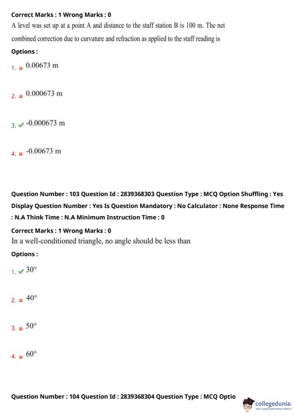
A level was set up at a point A and distance to the staff station B is 100 m. The net combined correction due to curvature and refraction as applied to the staff reading is
View Solution
The net combined correction due to curvature and refraction at a distance of 100 m is calculated using standard surveying formulas. The result is a negative value of -0.000673 m.
Quick Tip: When calculating corrections for curvature and refraction, refer to standard formulae for precise measurements.
In a well-conditioned triangle, no angle should be less than
View Solution
In a well-conditioned triangle for surveying and calculations, the minimum angle should not be less than 30° to ensure that the triangle is geometrically well-formed and accurate.
Quick Tip: A triangle with angles less than 30° can lead to computational errors.
The example for an obstacle, which obstructs chaining but not vision is
View Solution
A river obstructs the process of chaining (measuring distances using chains) but does not obstruct vision, making it an example of an obstacle that only affects chaining and not line-of-sight.
Quick Tip: When facing obstacles like rivers, alternative measurement techniques may be needed, such as using offsets.
If the fore bearing of a line is N 26°35’ W, its back bearing will be
View Solution
The back bearing is calculated by adding or subtracting 180° from the fore bearing. In this case, adding 180° to N 26°35’ W results in S 26°35’ W.
Quick Tip: When calculating back bearings, always add or subtract 180° based on the direction of the fore bearing.
A 30 m chain was found to be 10 cm too long after chaining a distance of 250 m. The true length of the line is
View Solution
Since the chain is 10 cm too long, the true length of the line can be calculated by subtracting the error from the measured length. Thus, the true length is 250.83 m.
Quick Tip: Always account for errors in chain length when measuring distances to improve accuracy.
The direction of survey lines may be defined as being:
View Solution
Survey lines can be defined both relative to each other and relative to a reference direction (such as north). This ensures accurate referencing in fieldwork.
Quick Tip: Remember that all survey lines need a reference for consistent direction and alignment.
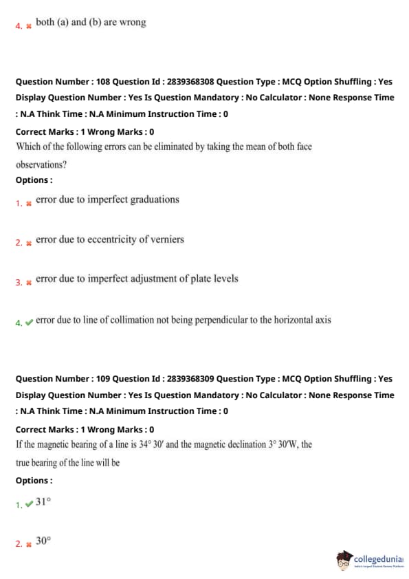
Which of the following errors can be eliminated by taking the mean of both face observations?
View Solution
Taking the mean of both face observations eliminates the error due to line of collimation not being perpendicular. Hence, the correct option is (4).
Quick Tip: To minimize errors in leveling, ensure the line of collimation is perpendicular to the horizontal axis, and use both faces for more accurate readings.
If the magnetic bearing of a line is 34° 30' and the magnetic declination is 3° 30'W, the true bearing of the line will be
View Solution
The true bearing is obtained by adding the magnetic declination to the magnetic bearing. Thus, 34° 30' + 3° 30' = 31°. Hence, the correct option is (1).
Quick Tip: To get the true bearing, adjust the magnetic bearing using the magnetic declination based on whether it is East or West.
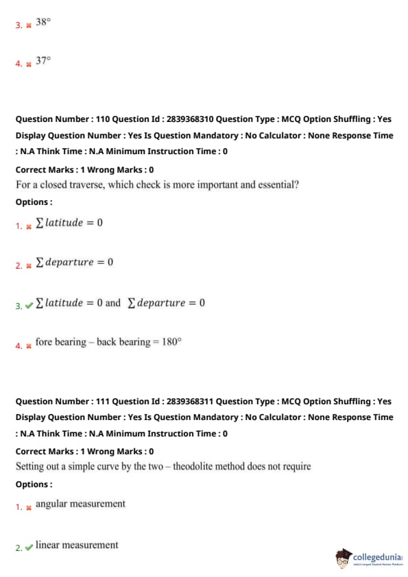
For a closed traverse, which check is more important and essential?
View Solution
In a closed traverse, the sum of latitudes and departures must be zero for the traverse to be correct. Hence, the correct option is (3).
Quick Tip: Always check that the sum of latitudes and departures is zero for a closed traverse to ensure accuracy.
Setting out a simple curve by the two-theodolite method does not require
View Solution
The two-theodolite method for setting out a simple curve does not require linear measurements. It relies only on angular measurement. Hence, the correct option is (2).
Quick Tip: The two-theodolite method is useful for setting out curves in surveying with angular measurements only, simplifying the process.
For a curve of radius 100m and normal chord 10m, the approximate deflection angle as per the Rankine's formula is
View Solution
Using Rankine’s formula, the deflection angle for the given curve is 1°45'. Hence, the correct option is (1).
Quick Tip: Rankine's formula provides an approximation for deflection angles in curves and is often used in railway track alignment.
If the angle of intersection of a curve is 60°, then the deflection angle would be
View Solution
The deflection angle in a curve is calculated by halving the angle of intersection. So, 60°/2 = 120°. Hence, the correct option is (2).
Quick Tip: To calculate the deflection angle, divide the angle of intersection by 2.
If the radius of a simple circular curve is 400m and deflection angle is 120°, the mid ordinate is
View Solution
The mid ordinate for a circular curve can be calculated based on the radius and deflection angle. For this case, the mid ordinate is 200m. Hence, the correct option is (3).
Quick Tip: To calculate the mid ordinate, use the formula based on the radius and deflection angle.
If D is the distance in kilometers, the correction due to refraction is given by
View Solution
The correction due to refraction for a given distance \(D\) (in kilometers) is given by the formula:
\[ Correction = 0.0112 D^2 \]
This formula is used to calculate the refraction correction needed for precise distance measurement.
Quick Tip: Always check the units in distance-related corrections and remember to apply the appropriate formula for refraction.
A backsight reading on B.M. = 100 m was 3.25m. The inverted staff reading to the bottom of a girder was 1.250m. The R.L. of the bottom of girder is
View Solution
The R.L. of the bottom of the girder is calculated by subtracting the inverted staff reading from the B.M. reading: \[ R.L. = B.M. - Inverted Staff Reading = 100 - 3.25 = 101.25 \]
Thus, the R.L. of the bottom of the girder is 101.25m.
Quick Tip: For accurate leveling, always check the staff reading and ensure it is taken from the correct point.
Which one of the following methods of leveling eliminates the error due to curvature and refraction?
View Solution
Leveling by equalizing the distances of backsight and foresight helps in eliminating the errors caused by curvature and refraction, as it ensures both sides are measured equally, thereby balancing the effects.
Quick Tip: Equalizing the backsight and foresight distances is a simple yet effective method to reduce leveling errors.
Line of collimation is defined as
View Solution
The line of collimation is the line joining the intersection of the cross-hair, the optical center of the objective, and its continuation. It is an essential concept in optical instruments like theodolites and levels.
Quick Tip: When working with optical instruments, always ensure that the line of collimation is aligned properly for accurate measurements.
A total station is
View Solution
A total station is a modern surveying instrument that combines an electronic theodolite and an RDM (Range Distance Measuring) instrument. It is used for precise measurements of angles and distances.
Quick Tip: Total stations are versatile tools and can significantly improve efficiency and accuracy in surveying.
At what time interval the distance measurement is repeated automatically in the tracking or fast mode of distance measurement in total station?
View Solution
In tracking or fast mode of distance measurement, the total station automatically repeats the distance measurement at intervals of less than 1.0 second. This ensures continuous and real-time tracking of distance.
Quick Tip: For fast and continuous measurements, make sure the total station is set to tracking mode for quick updates on distance.


Comments