


Kerala Plus Two 2025 Geography (SY-637) Model Question Paper with solutions PDFs are now available for download. The Kerala Plus Two Physics Model Examination 2025 was conducted by the Directorate of Higher Secondary Education (DHSE), Kerala, to help students prepare for the final board exams. The paper is designed as per the latest syllabus and exam pattern prescribed for the academic year 2025–26.
Kerala Plus Two 2025 Geography (SY-637) Model Question Paper with Solutions
| Kerala Plus Two 2025 Geography (SY-637) Model Question Paper | Check Solutions |

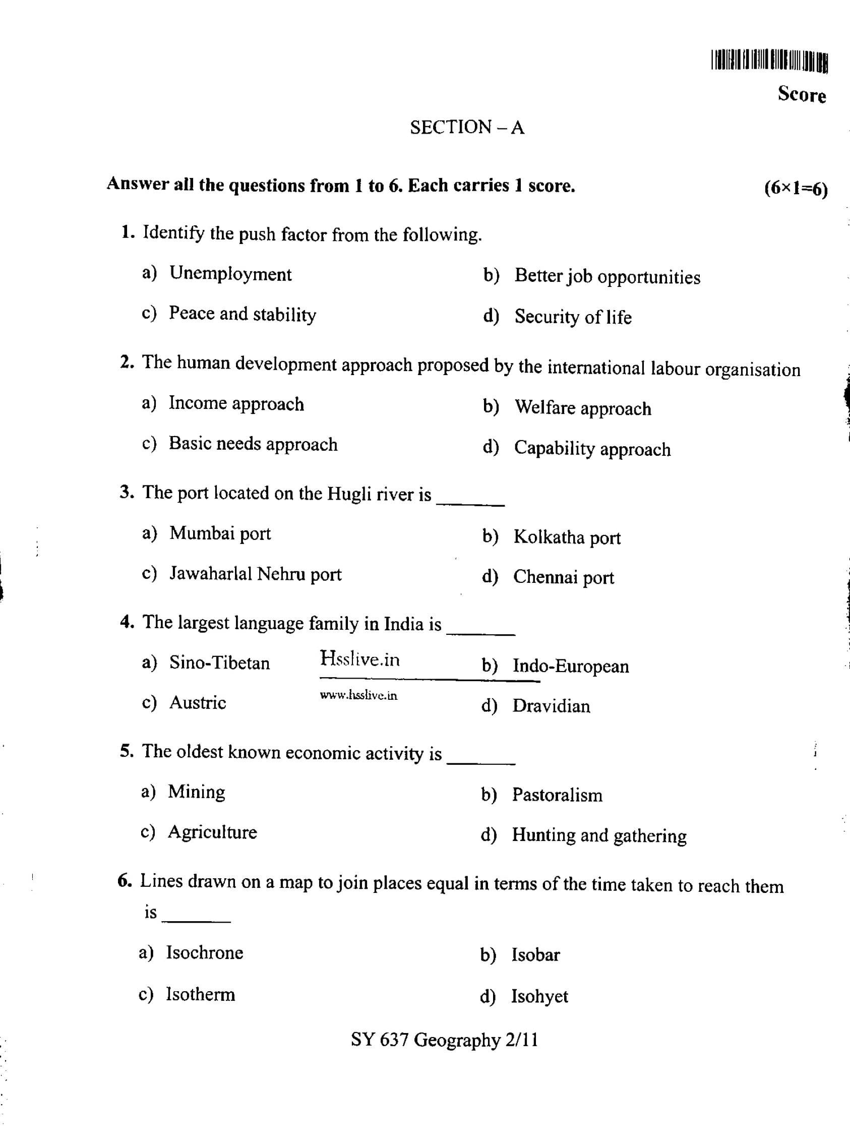
Identify the push factor from the following.
View Solution
Step 1: Understand the concept of push and pull factors.
Push factors are those factors that compel individuals to leave their current location due to negative conditions. These factors are often associated with hardship or poor living conditions. Examples include unemployment, poverty, poor healthcare, war, and political instability.
Pull factors, on the other hand, are those factors that attract people to a new location due to favorable conditions. Examples include better job opportunities, peace and stability, better living conditions, availability of resources, or personal safety.
Step 2: Analyze the given options.
- (A) Unemployment: This is a classic example of a push factor. People who face unemployment in their current place of residence are often forced to migrate to areas where job opportunities are available. Lack of employment opportunities makes individuals feel compelled to move to find work and improve their living conditions. Hence, unemployment pushes people to leave their current location in search of better economic prospects.
- (B) Better job opportunities: This is a pull factor. When people are attracted to a place because of better job opportunities, it signifies that they are drawn to that place due to the availability of employment. The pull factor attracts migrants towards a new location in search of economic advancement, career growth, or better working conditions. This is not a push factor, as it represents an incentive to move rather than a driving force to leave.
- (C) Peace and stability: These are typically pull factors. People are attracted to areas where there is peace and stability because it enhances their security and well-being. People may migrate to countries or regions that are peaceful and free of violence, as it improves their quality of life. Therefore, peace and stability is not a push factor.
- (D) Security of life: This is also a pull factor, similar to peace and stability. People tend to move to regions or countries where their lives are secure and safe. The lack of personal security in one location can lead to migration to another location where life is less threatened. Thus, security of life is a motivating factor for migration to safer places, making it a pull factor.
Step 3: Conclusion.
From the above analysis, it is clear that unemployment is the push factor. It is the negative condition that compels individuals to leave their homes in search of better living conditions and employment opportunities. Migration due to unemployment is a common phenomenon observed around the world, particularly in regions suffering from high levels of joblessness.
Step 4: Summary of Migration Factors.
To summarize, migration is influenced by both push and pull factors. Push factors such as unemployment drive individuals away from their current locations, while pull factors like better job opportunities and peace draw people to new places. Recognizing these factors is crucial for understanding the patterns and trends in human migration.
Final Answer:
Unemployment Quick Tip: Push factors lead to migration due to adverse conditions, while pull factors attract individuals to better conditions. Recognizing the difference is crucial for understanding migration patterns.
The human development approach proposed by the International Labour Organisation
View Solution
Step 1: Understand the human development approaches.
The International Labour Organisation (ILO) focuses on promoting social justice and fair labour practices. The approach proposed by the ILO for human development emphasizes the provision of basic needs to the population, ensuring that people have access to essential services such as food, shelter, education, and healthcare.
Step 2: Analyze the options.
- (A) Income approach: This approach emphasizes economic growth as the primary means of development. It focuses on increasing income levels but does not directly address the needs of the population in terms of basic services and welfare. This is not the approach proposed by the ILO.
- (B) Welfare approach: The welfare approach focuses on providing direct support to the disadvantaged. While it is an important approach, it is not specifically the one advocated by the ILO for long-term development.
- (C) Basic needs approach: The ILO proposed this approach, which emphasizes meeting the basic needs of individuals as the foundation for human development. It focuses on ensuring that everyone has access to essential services necessary for a decent standard of living.
- (D) Capability approach: This approach, proposed by Amartya Sen, focuses on enhancing individual capabilities and freedoms. While it is a significant approach to human development, it is not the one proposed by the ILO.
Step 3: Conclusion.
The correct answer is the Basic needs approach, as it was the one specifically proposed by the ILO to ensure that individuals' fundamental needs are met for overall development.
Final Answer:
Basic needs approach Quick Tip: The Basic Needs Approach emphasizes ensuring access to essential services such as food, healthcare, and education as key components of human development.
The port located on the Hugli river is
View Solution
Step 1: Understand the geographical context.
The Hugli river, also known as the Hooghly river, is a distributary of the Ganges river and flows through the state of West Bengal, India. It is an important river that has historically supported the development of trade and commerce in the region.
Step 2: Identify the port located on the Hugli river.
- Kolkatha port (now Kolkata port) is located on the banks of the Hugli river. It has been one of the most important ports in India, historically serving as the gateway to the eastern part of the country. It is the correct answer.
Step 3: Eliminate the incorrect options.
- Mumbai port is located on the west coast of India, along the Arabian Sea, and not on the Hugli river.
- Jawaharlal Nehru port is located in Navi Mumbai, Maharashtra, and is not located on the Hugli river.
- Chennai port is located on the east coast, along the Bay of Bengal, and is also not on the Hugli river.
Step 4: Conclusion.
The port located on the Hugli river is Kolkatha port (now Kolkata port), making it the correct answer.
Final Answer:
Kolkatha port Quick Tip: The Hugli river has played a crucial role in the development of Kolkata as a major trading and port city.
The largest language family in India is
View Solution
Step 1: Understand language families in India.
India is home to a wide variety of languages, which can be classified into several language families. These families are the basic classifications that group languages based on their historical and linguistic relationships. The major language families in India are: Indo-European, Dravidian, Sino-Tibetan, and Austric.
Step 2: Analyze the options.
- (A) Sino-Tibetan: This language family includes languages spoken in parts of the Northeast, like Tibetan and Burmese. While it is an important language family in India, it is not the largest.
- (B) Indo-European: The Indo-European family is the largest in India, encompassing most of the major languages spoken in India, including Hindi, Bengali, Marathi, Punjabi, and others. These languages are spoken by a large portion of the Indian population.
- (C) Austric: The Austric family is relatively smaller, and it includes languages like Santali and other tribal languages. It does not account for a significant portion of the population.
- (D) Dravidian: The Dravidian family includes languages spoken predominantly in southern India, such as Tamil, Telugu, Kannada, and Malayalam. While large, it is not as widespread as Indo-European.
Step 3: Conclusion.
The Indo-European family is by far the largest language family in India, as it includes the majority of languages spoken across the country.
Final Answer:
Indo-European Quick Tip: The Indo-European language family has the largest number of speakers in India, covering much of the northern and central parts of the country.
The oldest known economic activity is
View Solution
Step 1: Understand the context of early human economic activities.
The oldest known economic activity refers to the economic practices engaged in by early humans. These activities were essential for survival before the development of agriculture or domestication of animals.
Step 2: Analyze the options.
- (A) Mining: Mining, although an important economic activity in later human history, did not emerge as an activity until humans had developed tools and methods for extracting minerals. It is not the oldest economic activity.
- (B) Pastoralism: Pastoralism, or the domestication and herding of animals, is an ancient activity, but it developed after hunting and gathering. It did not precede hunting and gathering.
- (C) Agriculture: Agriculture is a more recent development in human history, emerging after the establishment of hunting and gathering practices. The first known evidence of agriculture appears around 10,000 BCE.
- (D) Hunting and gathering: This is the oldest known economic activity. Early human societies were primarily hunter-gatherers, relying on the collection of wild plants and hunting animals for food, long before the development of agriculture or pastoralism.
Step 3: Conclusion.
The correct answer is Hunting and gathering, as it predates all other forms of economic activity and was practiced by early humans for thousands of years.
Final Answer:
Hunting and gathering Quick Tip: Hunting and gathering were essential for early human societies, and only later did agriculture and pastoralism emerge as major economic activities.
Lines drawn on a map to join places equal in terms of the time taken to reach them is
View Solution
Step 1: Understand the concept of isochrone.
An isochrone is a line on a map that connects places which can be reached in the same amount of time from a particular origin. It is often used to visualize travel times or accessibility to different areas from a given point, for example, showing the time it takes to reach various points by road, rail, or air.
Step 2: Analyze the other options.
- Isobar: An isobar is a line on a map or chart that connects points of equal atmospheric pressure. It is used in meteorology to indicate pressure variations and is unrelated to time-based travel.
- Isotherm: An isotherm is a line on a map that joins places having the same temperature. It is used in climate studies to show regions with similar temperature conditions.
- Isohyet: An isohyet is a line on a map that connects points receiving equal amounts of rainfall over a specific period. It is used in hydrology and meteorology to represent precipitation levels.
Step 3: Conclusion.
The correct answer is Isochrone, as it specifically refers to lines that represent equal travel times or distances to locations.
Final Answer:
Isochrone Quick Tip: Isochrones are particularly useful in transportation planning and geography to illustrate accessibility and travel times.
Write a brief note on Green Revolution.
View Solution
The Green Revolution in India refers to a period of significant agricultural modernization that began in the 1960s. It was aimed at increasing food production and making India self-sufficient in food grains. The revolution was driven by the introduction of high-yielding variety (HYV) seeds, advanced irrigation techniques, chemical fertilizers, and the mechanization of agriculture. The primary focus of the Green Revolution was on increasing the production of staple crops such as wheat and rice.
Key Features of the Green Revolution:
- High-Yielding Variety (HYV) Seeds: The introduction of new, improved seeds that produced higher crop yields.
- Irrigation: The development of efficient irrigation methods to ensure a stable water supply for crops, especially in dry areas.
- Fertilizers and Pesticides: The increased use of chemical fertilizers and pesticides to promote growth and protect crops.
- Mechanization: The introduction of modern machinery such as tractors and harvesters to increase efficiency and reduce manual labor.
Impact of the Green Revolution:
- Increased Food Production: The Green Revolution significantly boosted India's food production, particularly in wheat and rice, making India self-sufficient in food grains.
- Economic Growth: Agricultural productivity increased, leading to higher incomes for farmers in certain regions, especially Punjab and Haryana.
- Regional Disparities: The benefits of the Green Revolution were not evenly distributed, leading to regional imbalances in agricultural development.
- Environmental Concerns: The overuse of fertilizers and pesticides led to soil degradation, water shortages, and environmental pollution.
Conclusion:
The Green Revolution played a key role in improving food security in India, but it also had social and environmental consequences that need to be addressed through sustainable agricultural practices. Quick Tip: The Green Revolution significantly improved agricultural productivity but also highlighted the need for environmentally sustainable farming practices.
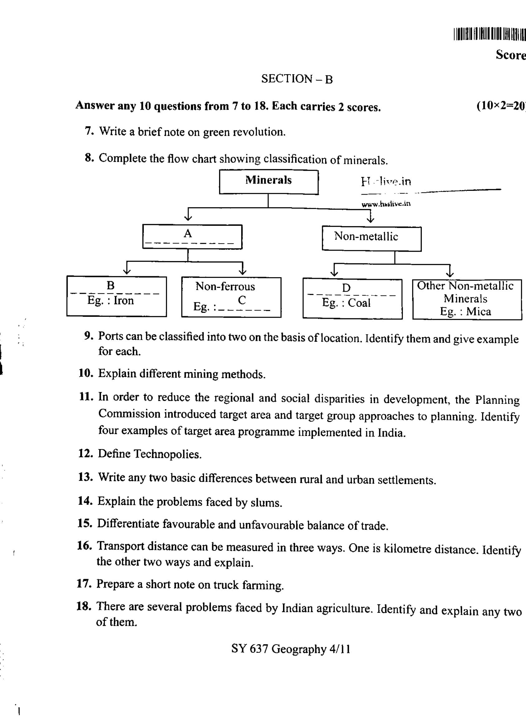
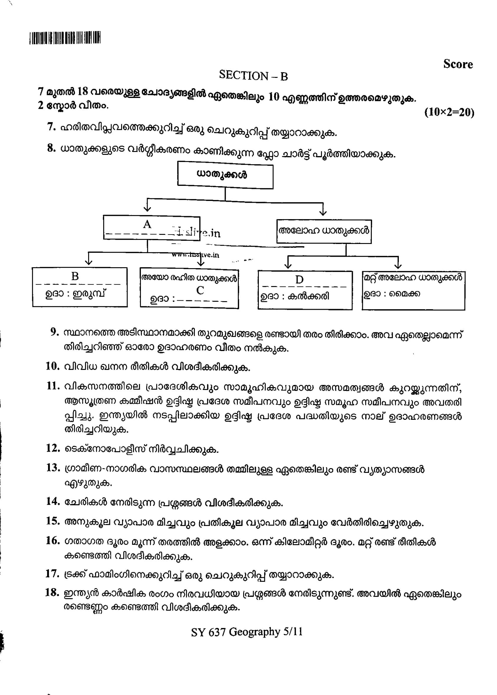
Complete the flow chart showing classification of minerals.

View Solution
Below is the completed flow chart showing the classification of minerals:
Minerals
\hspace{2cm \(\downarrow\)
Metallic \hspace{1cm \(\longrightarrow\) \hspace{1cm Non-metallic
\hspace{2cm \(\downarrow\)
Ferrous \hspace{1cm \(\longrightarrow\) \hspace{1cm Non-ferrous \hspace{1cm \(\longrightarrow\) \hspace{1cm Other Non-metallic Minerals
\hspace{2cm \(\downarrow\) \hspace{0.5cm \(\downarrow\) \hspace{1.5cm \(\downarrow\)
B : Iron \hspace{0.5cm C : Copper \hspace{0.5cm D : Coal \hspace{0.5cm Mica
Explanation of the Flowchart:
- Ferrous Minerals: These minerals contain iron and are primarily used in the manufacturing of steel. Example: Iron Ore.
- Non-ferrous Minerals: These do not contain iron but are valuable for various industries such as electronics, construction, and manufacturing. Example: Copper.
- Other Non-metallic Minerals: These include minerals used in non-metallic applications like mica, which is essential in electrical industries. Quick Tip: Ferrous minerals are those that contain iron, while non-ferrous minerals do not, and are important in industries such as electronics and construction.
Ports can be classified into two on the basis of location. Identify them and give example for each.
View Solution
Ports can be classified into two main types based on their location: natural ports and artificial ports.
1. Natural Ports
Natural ports are formed naturally by geographical features such as bays, gulfs, and inlets. These ports are sheltered and provide a safe harbor for ships to dock. Natural ports usually require minimal human intervention to make them suitable for docking and loading/unloading goods.
Example: The Port of Mumbai in India is a natural port formed by a deep inlet along the coast. It has been one of the busiest and most important ports in India.
2. Artificial Ports
Artificial ports are human-made structures built to accommodate the docking of ships. These ports are constructed to provide sheltered harbors and are created by building breakwaters, jetties, and other infrastructure to modify the natural coastline. These ports are often built in locations that lack natural harbors.
Example: The Port of Rotterdam in the Netherlands is an artificial port. It is one of the largest ports in Europe and was created by extensive dredging and construction along the North Sea coastline.
Thus, the two main types of ports based on location are natural ports and artificial ports, with Mumbai and Rotterdam serving as examples.
Quick Tip: Natural ports are formed by geographical features, while artificial ports are constructed by humans to provide better facilities for shipping and trade.
Explain different mining methods.
View Solution
Mining methods refer to the techniques used to extract valuable minerals and ores from the earth. The method used depends on factors like the type of mineral, its location, depth, and environmental considerations. The main mining methods are as follows:
1. Open-Pit Mining
Open-pit mining is a surface mining method used when minerals are located near the surface. It involves digging a large, stepped excavation (pit) in the ground to extract the ore. This method is commonly used for minerals like gold, copper, and coal. It is cost-effective but can have significant environmental impacts.
Example: The Bingham Canyon Mine in Utah, USA, is one of the largest open-pit mines in the world.
2. Underground Mining
Underground mining is used when the mineral deposit is deep below the earth's surface and cannot be mined using surface methods. It involves creating tunnels or shafts to access the ore. While more expensive than open-pit mining, it is less destructive to the environment.
Example: The Cerro Rico mine in Bolivia is an example of underground mining, where silver and tin ores are extracted.
3. Placer Mining
Placer mining is used to extract gold and other precious metals from riverbeds or alluvial deposits. This method involves using water to wash away lighter materials, leaving behind heavier minerals like gold. It can be done manually or with mechanical equipment.
Example: The Yukon River in Canada has been a site of placer mining for gold since the 19th century.
4. Mountaintop Removal Mining
Mountaintop removal mining is a type of surface mining that involves blasting off the top of a mountain to reach coal deposits underneath. This method is controversial due to its significant environmental impact, including deforestation, habitat destruction, and water pollution.
Example: Appalachian coal mining in the United States uses this method to extract coal from mountains in the region.
5. Room and Pillar Mining
Room and pillar mining is commonly used in the extraction of coal and other minerals. It involves creating tunnels (rooms) in the deposit and leaving behind pillars of material to support the mine's roof. This method is usually used in shallow, horizontal ore deposits.
Example: Salt mines in various parts of the world, such as the Harrison County Salt Mine in the USA, use this method.
6. Solution Mining
Solution mining involves dissolving the mineral in water and pumping the resulting solution to the surface. It is commonly used for minerals like salt, potash, and uranium. This method has a relatively low environmental impact compared to traditional mining methods.
Example: Uranium mining in Saskatchewan, Canada, uses solution mining for extracting uranium from underground ore bodies.
In conclusion, different mining methods are employed based on the type and location of the mineral deposits. These methods vary in terms of cost, environmental impact, and efficiency. Quick Tip: Mining methods include open-pit, underground, placer, mountaintop removal, room and pillar, and solution mining. Each method is chosen based on the characteristics of the mineral deposit.
In order to reduce the regional and social disparities in development, the Planning Commission introduced target area and target group approaches to planning. Identify four examples of target area programme implemented in India.
View Solution
In India, the Planning Commission introduced target area and target group approaches to planning to address regional and social disparities. These approaches aimed to focus resources on specific areas or groups that needed special attention. Some examples of target area programmes implemented in India are:
Step 1: Integrated Rural Development Programme (IRDP).
The IRDP aimed at improving the living standards of the rural poor by providing them with financial assistance for productive assets and employment generation activities. It focused on rural areas with a high concentration of poverty.
Step 2: Drought Prone Area Programme (DPAP).
DPAP was launched to mitigate the effects of drought in the arid and semi-arid regions of India. The programme focused on water conservation, drought-resistant crops, and improving irrigation facilities in drought-prone areas.
Step 3: Desert Development Programme (DDP).
The DDP was aimed at tackling desertification in the desert areas of Rajasthan and Gujarat. The programme focused on soil conservation, afforestation, and the improvement of water resources.
Step 4: Tribal Sub-Plan (TSP).
The Tribal Sub-Plan focused on the socio-economic development of the tribal population in India. It aimed to ensure the inclusion of tribal areas in the mainstream development process by providing them with specialized welfare and development schemes.
Step 5: Conclusion.
These target area programmes were designed to address specific issues faced by underdeveloped regions or communities, contributing to the overall goal of balanced and inclusive development in India.
Quick Tip: Target area programmes play a crucial role in addressing regional and social inequalities by focusing on specific areas or groups requiring special attention.
Define Technopolies.
View Solution
Technopolies refer to societies or economies where technological development dominates all aspects of life, including social, cultural, and political structures. The term was popularized by Neil Postman in his book Technopoly: The Surrender of Culture to Technology (1992). In a technopoly, technology is not only pervasive but is seen as the central organizing force of society, often at the expense of traditional values, social structures, and human interactions.
Step 1: Technological Dominance.
In a technopoly, technology controls how people live, work, and think. The society’s dependency on technology increases to the point where it begins to dictate societal norms, education, and governance.
Step 2: Impact on Culture and Society.
Technopolies can result in the erosion of traditional cultures, as technology becomes the primary force of change. Human relationships and cultural practices may be replaced by technological solutions, leading to a loss of community and individual autonomy.
Step 3: Conclusion.
Technopolies highlight the potential dangers of excessive reliance on technology, where innovation and technical progress overshadow other aspects of human life, including ethical, cultural, and social values.
Quick Tip: While technology offers progress, a technopoly raises concerns about the overdependence on technology and its impact on cultural and social values.
Write any two basic differences between rural and urban settlements.
View Solution
Rural and urban settlements are two different types of human settlements, each with distinct characteristics. Here are two basic differences between them:
Step 1: Population Density.
- Rural Settlements: These settlements have a low population density, meaning fewer people live in a larger area. Rural areas are often spread out, with more open space and fewer buildings.
- Urban Settlements: Urban areas are characterized by high population density, with a large number of people living in a relatively small area. Cities are densely packed with buildings, infrastructure, and a constant flow of people.
Step 2: Economic Activities.
- Rural Settlements: The economy in rural areas is primarily based on agriculture, farming, and natural resource exploitation. People in rural settlements are often involved in activities like farming, animal husbandry, and handicrafts.
- Urban Settlements: Urban areas have a diverse economy, with people engaged in a wide range of activities such as manufacturing, services, trade, and technology. The economic activities in cities are generally industrial and commercial. Quick Tip: Rural settlements are often focused on agriculture and have lower population densities, while urban settlements are economically diverse and densely populated.
Explain the problems faced by slums.
View Solution
Slums are densely populated areas characterized by poor living conditions, inadequate infrastructure, and a lack of basic services. The problems faced by slums are numerous and affect the residents' health, well-being, and social mobility. The following are some of the key issues faced by slum dwellers:
Step 1: Lack of Basic Infrastructure.
Slums often lack proper infrastructure such as roads, clean water supply, sanitation, and electricity. These deficiencies make daily life difficult for the residents, leading to health hazards and poor living conditions. Access to public services is limited or entirely absent, making it difficult for slum dwellers to improve their situation.
Step 2: Overcrowding.
Slums are characterized by overcrowding, where many people live in cramped and inadequate spaces. This increases the risk of disease transmission and creates unhealthy living conditions. The lack of space also leads to a lack of privacy and often results in social tensions among residents.
Step 3: Health and Hygiene Issues.
Due to poor sanitation, improper waste disposal, and inadequate access to clean drinking water, slum residents are highly susceptible to diseases such as cholera, dysentery, and respiratory infections. The overcrowded conditions exacerbate the spread of infectious diseases.
Step 4: Unemployment and Poverty.
Many people living in slums struggle to find stable employment due to a lack of education and skills. As a result, poverty levels remain high, and many residents engage in informal or low-paying jobs with no job security. This economic instability further contributes to the cycle of poverty in slums.
Step 5: Social Exclusion and Marginalization.
Slum dwellers often face social exclusion, as they are marginalized from the mainstream society due to their poor living conditions. They may be excluded from accessing basic services, education, and healthcare, which limits their opportunities for social mobility and perpetuates the cycle of poverty. Quick Tip: Slums face multiple challenges, including poor infrastructure, overcrowding, inadequate healthcare, and limited economic opportunities, making it difficult for residents to escape poverty.
Differentiate favourable and unfavourable balance of trade.
View Solution
The balance of trade refers to the difference between the value of a country's exports and imports of goods. A favourable balance of trade occurs when a country exports more than it imports, while an unfavourable balance of trade occurs when a country imports more than it exports.
1. Favourable Balance of Trade:
A favourable balance of trade, also known as a trade surplus, occurs when the value of a country's exports exceeds the value of its imports. This is considered beneficial for the economy, as it indicates that the country is earning more from selling goods abroad than it is spending on foreign goods. A favourable balance of trade can lead to an increase in foreign exchange reserves, strengthening the national currency and boosting economic growth.
- Example: If a country exports \(100 million worth of goods and imports only \)80 million, it has a trade surplus of \(20 million. 2. \textbf{Unfavourable Balance of Trade:} An unfavourable balance of trade, also known as a trade deficit, occurs when a country imports more goods than it exports. This situation is considered detrimental to the economy because it means that the country is spending more on foreign goods than it is earning from its own exports. A trade deficit can lead to a depletion of foreign exchange reserves, cause a depreciation of the national currency, and increase external debt. - Example: If a country exports \)80 million worth of goods but imports \(100 million, it has a trade deficit of \)20 million.
Conclusion:
In summary, a favourable balance of trade is when exports exceed imports, leading to a surplus, while an unfavourable balance of trade is when imports exceed exports, leading to a deficit. A trade surplus is generally seen as positive for the economy, while a trade deficit may raise concerns about the country’s financial stability. Quick Tip: A favourable balance of trade boosts the economy by generating income from exports, while an unfavourable balance can strain economic resources and lead to currency depreciation.
Transport distance can be measured in three ways. One is kilometre distance. Identify the other two ways and explain.
View Solution
In the field of transportation, distance can be measured in various ways to assess the cost, efficiency, and accessibility of transport routes. Apart from the standard kilometre distance, the two other ways to measure transport distance are:
1. Time Distance:
Time distance refers to the time taken to travel from one point to another, considering the mode of transportation used. It is a more practical measure than kilometre distance because it accounts for factors like speed, road conditions, traffic congestion, and stops along the way. Time distance helps businesses and individuals determine how long it will take to transport goods or travel from one location to another.
- Example: A truck may cover 50 kilometres in an hour on an expressway, but it may take 1.5 hours to cover the same distance if there is heavy traffic or poor road conditions.
2. Economic Distance:
Economic distance refers to the cost of transporting goods over a particular distance. This measure takes into account not only the physical distance but also the cost of fuel, tolls, labor, and other expenses related to transport. Economic distance is crucial for businesses in determining the most cost-effective routes and optimizing supply chain operations.
- Example: Even though two cities may be 100 kilometres apart, the economic cost of transportation might vary significantly depending on factors such as the price of fuel, tolls on highways, and labor costs.
Conclusion:
In conclusion, transport distance can be measured in several ways, including kilometre distance, time distance, and economic distance. While kilometre distance provides a basic physical measure, time and economic distance offer more practical insights into transportation efficiency and cost. Quick Tip: Time distance considers the duration of travel, while economic distance takes into account the cost of transportation, both of which are important for efficient logistics and planning.
Prepare a short note on truck farming.
View Solution
Truck farming refers to the commercial production of vegetables, fruits, and other crops, which are typically sold in local markets or transported over long distances to urban areas. The term "truck" in this context is derived from the old English word "truck," meaning "barter" or "exchange." In truck farming, crops are grown specifically for market sales rather than for personal consumption. This type of farming is commonly found in regions with favorable climates for vegetable and fruit production.
Key Characteristics of Truck Farming:
1. Location: Truck farming is typically practiced in areas near urban centers, as these areas offer easy access to markets for the fresh produce. It is common in the United States (e.g., California, Florida), as well as parts of Europe and Asia.
2. Diverse Crop Production: Farmers engage in growing a wide variety of crops such as tomatoes, lettuce, cucumbers, melons, and berries. These crops are typically perishable and require quick transportation to markets to ensure freshness.
3. Seasonal and Intensive Farming: The farming process is highly intensive and often involves the use of modern farming techniques and technologies. The crops are usually grown in smaller areas compared to traditional farming, and farming operations are seasonal, often timed to meet market demand.
4. Transportation: As the term "truck" suggests, produce from truck farming is often transported by trucks to local, regional, or even international markets, making transportation a critical component of the process.
Truck farming plays a significant role in providing fresh produce to cities and contributes to local economies. It also helps farmers take advantage of urban markets and high-value crops. Quick Tip: Truck farming involves growing fruits and vegetables for market sale, and it is typically practiced near urban centers to ensure the quick transportation of perishable produce.
There are several problems faced by Indian agriculture. Identify and explain any two of them.
View Solution
Indian agriculture faces a number of challenges that affect its productivity and sustainability. Two significant problems that Indian agriculture faces are:
1. Dependence on Monsoon
Agriculture in India heavily relies on the monsoon season for water supply, as a large portion of the country’s agricultural land is rainfed. The irregularity of monsoons, droughts, and floods can severely affect crop yields. In regions where irrigation infrastructure is inadequate, the dependence on seasonal rainfall increases the vulnerability of crops to water scarcity. This leads to instability in agricultural production and farmers' incomes.
2. Fragmentation of Land Holdings
The average size of land holdings in India is small and fragmented. Most farmers own small parcels of land, which makes it difficult to adopt modern farming techniques, machinery, and efficient irrigation systems. This fragmentation limits economies of scale, increases production costs, and leads to inefficient farming practices. Small landholdings often result in lower productivity and make it harder for farmers to sustain their livelihoods.
Both of these issues highlight the need for better irrigation infrastructure, land reforms, and technological interventions to improve agricultural productivity and ensure long-term sustainability. Quick Tip: Indian agriculture faces problems such as dependence on the monsoon for water and the fragmentation of land holdings, which affect productivity and make farming vulnerable to environmental changes.
Point out the advantages of non-conventional energy resources.
View Solution
Non-conventional energy resources refer to energy sources that are renewable, sustainable, and less harmful to the environment compared to conventional fossil fuels. Some key advantages of non-conventional energy resources include:
Step 1: Environmentally Friendly.
Non-conventional energy resources like solar, wind, and hydroelectric power produce little to no pollution, reducing the harmful impact on air quality, water resources, and ecosystems. They help in reducing greenhouse gas emissions and combating climate change.
Step 2: Renewable and Sustainable.
Unlike fossil fuels, non-conventional energy sources are renewable, meaning they can be replenished naturally and are not finite. For example, solar and wind energy are inexhaustible as long as the sun shines and the wind blows.
Step 3: Energy Security.
By utilizing local non-conventional energy resources, countries can reduce their dependence on imported fossil fuels, ensuring energy security and stabilizing their energy markets.
Step 4: Economic Benefits.
The development and use of non-conventional energy resources can create jobs, particularly in sectors such as solar panel manufacturing, wind turbine installation, and maintenance services. It can also drive economic growth through innovation in green technologies.
Step 5: Conclusion.
Non-conventional energy resources are crucial for ensuring long-term energy sustainability, reducing environmental impacts, and promoting economic development.
Quick Tip: Non-conventional energy sources offer a cleaner and more sustainable alternative to fossil fuels, benefiting both the environment and the economy.
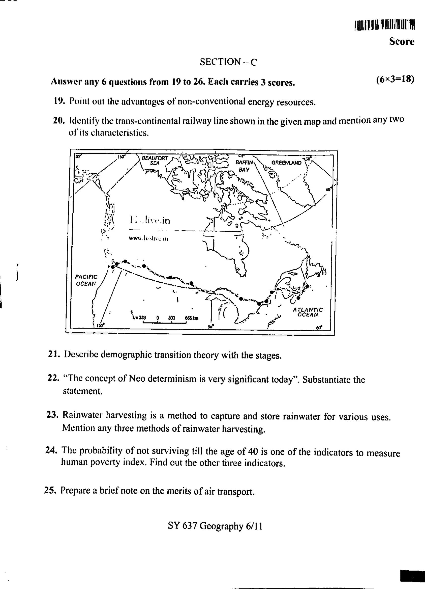
Identify the trans-continental railway line shown in the given map and mention any two characteristics.

View Solution
The trans-continental railway line shown in the given map is the Trans-Siberian Railway. This railway network spans from the western part of Russia (Moscow) to the far eastern part (Vladivostok), covering approximately 9,289 kilometers.
Step 1: Characteristics of the Trans-Siberian Railway.
1. Longest Railway Line in the World: The Trans-Siberian Railway is the longest railway line in the world, connecting Europe to Asia through Russia. It crosses multiple time zones and offers a direct link between Moscow and Vladivostok.
2. Strategic and Economic Importance: The railway plays a vital role in the movement of goods and passengers across Russia, particularly for transporting raw materials, oil, and gas from Siberia to other parts of Russia and international markets. It also serves as a major transport route for tourists and travelers.
Step 2: Conclusion.
The Trans-Siberian Railway is a key infrastructure project that has contributed significantly to Russia's economic development, connecting vast areas of the country and facilitating trade and tourism.
Quick Tip: The Trans-Siberian Railway remains an iconic part of global rail travel, offering both commercial and tourism-related benefits.
Describe demographic transition theory with the stages.
View Solution
Demographic transition theory explains the change in population growth patterns as a country industrializes and modernizes. The theory is divided into four (or sometimes five) stages, reflecting changes in birth rates, death rates, and overall population growth. Let’s explore these stages:
Step 1: Stage 1 - Pre-Industrial Society.
In this stage, both birth rates and death rates are high, leading to a stable or very slow-growing population. High birth rates occur due to limited access to contraception and the importance of large families in an agrarian society. High death rates are caused by poor sanitation, famine, disease, and a lack of medical knowledge. Population growth is minimal or fluctuates due to these factors.
Step 2: Stage 2 - Early Expanding.
In this stage, death rates begin to fall due to improvements in sanitation, healthcare, and food production. However, birth rates remain high, as cultural factors such as the need for labor and lack of family planning prevent a decrease in births. The result is rapid population growth. This stage often corresponds to countries that are beginning to industrialize, such as in parts of Africa and Asia today.
Step 3: Stage 3 - Late Expanding.
In this stage, birth rates begin to decline due to factors such as increased access to contraception, changes in social norms, urbanization, and improvements in women's education. Although birth rates are still higher than death rates, the decline in birth rates slows population growth. Many developing countries, such as India and Brazil, are in this stage, where population growth is more controlled.
Step 4: Stage 4 - Low Stationary.
At this stage, both birth rates and death rates are low, leading to a stable or slowly growing population. Countries in this stage have advanced economies with high standards of living, widespread access to healthcare, and low fertility rates. Developed countries such as the United States, Japan, and much of Western Europe are in this stage. Birth rates are low due to urbanization, career-focused lifestyles, and access to family planning.
Step 5: Stage 5 - Declining.
Some demographers add a fifth stage, where birth rates fall below death rates, leading to a declining population. This stage is associated with highly developed countries, such as Japan and some European countries, where the fertility rate is below replacement level. In these countries, the population is shrinking, leading to concerns about labor shortages and the economic impact of an aging population. Quick Tip: The demographic transition model explains the shift from high birth and death rates to low birth and death rates as countries undergo social and economic development.
"The concept of Neo determinism is very significant today". Substantiate the statement.
View Solution
Neo determinism is a modern concept that combines the ideas of determinism with the recognition of human agency and choice. It is based on the belief that while certain factors, such as geography, technology, or social structures, may shape human behavior and society, individuals and societies also have the power to influence and change their circumstances. This contrasts with classical determinism, which suggests that human behavior is strictly shaped by external factors like environment or biology.
Step 1: Explanation of Neo Determinism.
Neo determinism acknowledges that certain elements like geography, technology, and historical events play a significant role in shaping the development of societies. For instance, the geography of a region may limit its access to resources or influence its economic activities. However, it also recognizes that human beings have the capacity for creativity, innovation, and decision-making, allowing them to transcend some of these limitations. This perspective emphasizes the dynamic interaction between external conditions and human choices.
Step 2: Relevance of Neo Determinism in Today's World.
In today's globalized and rapidly changing world, neo determinism is highly relevant as it reflects the ongoing debates about the role of technology, culture, and environment in shaping human society. For example, while climate change and technological advancements are often seen as determinative factors in shaping global policies, individuals and nations can still make choices that alter the trajectory of these processes. The rise of social movements, environmental activism, and technological innovations in sectors such as clean energy and digital connectivity illustrates the influence of human agency in the face of external challenges.
Step 3: Examples of Neo Determinism in Practice.
- Climate Change and Sustainability: While the impacts of climate change are largely determined by global environmental changes, individuals and nations still have the power to take actions, such as reducing carbon emissions or adopting sustainable practices, to mitigate its effects.
- Technological Advancements: The rise of the internet, artificial intelligence, and digital technologies has fundamentally reshaped economies and societies, but human agency in the form of policy decisions, ethical considerations, and technological innovations will continue to influence how these advancements unfold. Quick Tip: Neo determinism highlights the interplay between external factors and human agency, emphasizing that while circumstances shape outcomes, individuals can still influence and change their environment.
Rainwater harvesting is a method to capture and store rainwater for various uses. Mention any three methods of rainwater harvesting.
View Solution
Rainwater harvesting is an ancient practice that helps conserve water by capturing rainwater for use in irrigation, drinking, and other purposes. There are several methods of rainwater harvesting, and the three most common methods include:
1. Rooftop Rainwater Harvesting:
In this method, rainwater is collected from rooftops and stored in tanks or reservoirs for later use. A system of pipes and filters is used to channel the rainwater from the roof into storage containers, ensuring that the water is clean and ready for use.
- Example: A house with a sloped roof collects rainwater from the roof surface, which is then directed to a storage tank.
2. Surface Runoff Harvesting:
Surface runoff harvesting involves capturing rainwater that flows over land surfaces, such as fields, roads, and pavements, during a rainfall. The water is collected in small ponds or reservoirs built to collect and store water for agricultural or domestic use.
- Example: Constructing a small reservoir or trench along a road to collect rainwater that runs off during heavy rainfall.
3. Check Dams and Nala (Stream) Harvesting:
Check dams are small barriers built across small streams or rivers to capture and store rainwater. This method allows water to seep into the ground, recharging groundwater levels while also providing water for agricultural and domestic use.
- Example: Building small dams along seasonal streams to collect rainwater and prevent it from flowing into larger water bodies.
Conclusion:
Rainwater harvesting plays an essential role in water conservation, especially in areas facing water scarcity. By utilizing these methods, we can conserve water and help maintain sustainable water supplies. Quick Tip: Rooftop harvesting, surface runoff harvesting, and check dams are effective methods of capturing and storing rainwater for various uses.
The probability of not surviving till the age of 40 is one of the indicators to measure human poverty index. Find out the other three indicators.
View Solution
The Human Poverty Index (HPI) is a composite index used to measure the level of poverty in a population, beyond just income measures. It is designed to highlight the level of deprivation in key dimensions of human life. In addition to the probability of not surviving till the age of 40, the other three indicators of the HPI are:
1. Adult Literacy Rate:
This indicator measures the proportion of adults who are literate in a population. Low literacy rates reflect poor access to education and contribute to higher levels of poverty, as individuals without education often lack the skills to improve their socio-economic status.
2. Access to Clean Water:
This indicator measures the percentage of the population that has access to safe drinking water. Lack of access to clean water is a major cause of health issues and contributes to high poverty levels, as it results in high mortality rates and prevents economic productivity.
3. Income Poverty (or Access to Basic Services):
This indicator refers to the proportion of people living below the poverty line, unable to meet basic needs such as food, shelter, and healthcare. It measures the extent of income deprivation and access to essential services.
Conclusion:
The Human Poverty Index uses indicators such as adult literacy, access to clean water, and income poverty to provide a more comprehensive measure of poverty, considering both economic and social factors. Quick Tip: The HPI is a more holistic measure of poverty, considering education, health, and living conditions, in addition to income levels.
Prepare a brief note on the merits of air transport.
View Solution
Air transport is a fast, efficient, and convenient mode of transportation, especially for long distances. It offers numerous advantages that make it an important part of global travel and trade systems. Below are the key merits of air transport:
1. Speed and Efficiency:
Air transport is the fastest mode of transportation, especially for long-distance travel. It significantly reduces travel time compared to road or rail transport, making it ideal for business, tourism, and emergency services. Airplanes can cover vast distances in a short period, making them the preferred choice for international travel and cargo shipments.
2. Global Connectivity:
Air transport connects even the most remote areas to the global network, facilitating international trade, travel, and cultural exchange. It provides access to locations that are not easily reachable by land or sea, helping bridge distances between countries and continents.
3. Safety:
Air travel is one of the safest modes of transportation. The strict regulations, continuous monitoring, and advanced technology used in aviation ensure high safety standards. The risk of accidents is comparatively low, making air travel a reliable option for passengers.
4. Carrying Capacity:
Air transport is capable of carrying large volumes of goods over long distances. Cargo planes can transport heavy and bulky items, such as machinery, electronics, and perishables, quickly and efficiently. This is especially important in the context of global trade.
5. Convenience:
Airlines offer regular and scheduled services, making it easy for passengers to plan their travel according to their convenience. In addition, air travel is often more comfortable and offers a range of services, such as in-flight entertainment, meals, and baggage handling, which enhance the overall travel experience.
Conclusion:
In conclusion, air transport plays a crucial role in connecting people and goods around the world. Its speed, global reach, safety, and capacity make it an essential mode of transportation in today's interconnected world. Quick Tip: Air transport is the fastest and most efficient mode of travel for long distances, offering global connectivity and high safety standards.
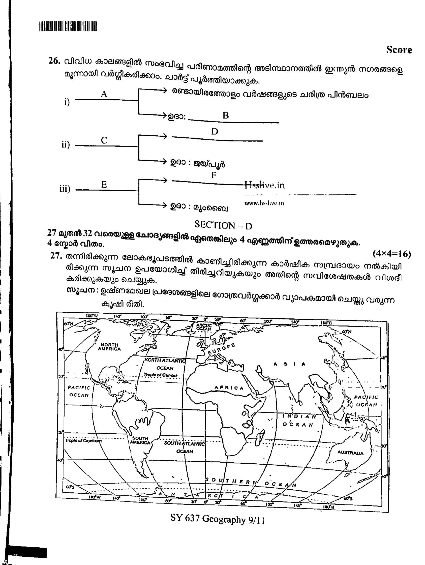
On the basis of evolution in different periods, Indian towns can be classified into three. Complete the chart.

View Solution
Indian towns have evolved over different periods, and based on their historical development, they can be categorized into three types. Let’s analyze the chart:
i) A: Ancient towns
These towns have a historical background spanning over 2000 years. They were often developed as centers for trade, administration, or religious activities. These towns have a rich heritage and historical significance.
Eg: B: Varanasi, one of the oldest cities in the world with a history of over 2000 years, and D: Ujjain, another ancient city with deep religious roots and historical importance.
ii) C: Medieval towns
These towns emerged during the medieval period, particularly under various dynasties and rulers. They became centers of culture, politics, and commerce, and have a distinct medieval character.
Eg: Jaipur is a planned city built in the 18th century by Maharaja Jai Singh II and represents a typical medieval town with its grid-like structure and historical palaces.
F: Delhi is another example, being the capital of various Mughal and medieval dynasties.
iii) E: Modern towns
These towns developed during the British colonial period and in the post-independence era, incorporating modern infrastructure, industrial development, and urbanization. They have grown rapidly, becoming metropolitan cities.
Eg: Mumbai, which evolved into a major port city and financial hub of India, is a prime example of modern urban development.
Thus, the completed chart is:
i) A: Ancient towns \hspace{2cm \text{Eg: B: Varanasi \hspace{3cm \text{D: Ujjain
ii) C: Medieval towns \hspace{2cm \text{Eg: Jaipur \hspace{3cm \text{F: Delhi
iii) E: Modern towns \hspace{2cm \text{Eg: Mumbai Quick Tip: Indian towns evolved through ancient, medieval, and modern periods, each with distinct historical and cultural influences that shaped their development.
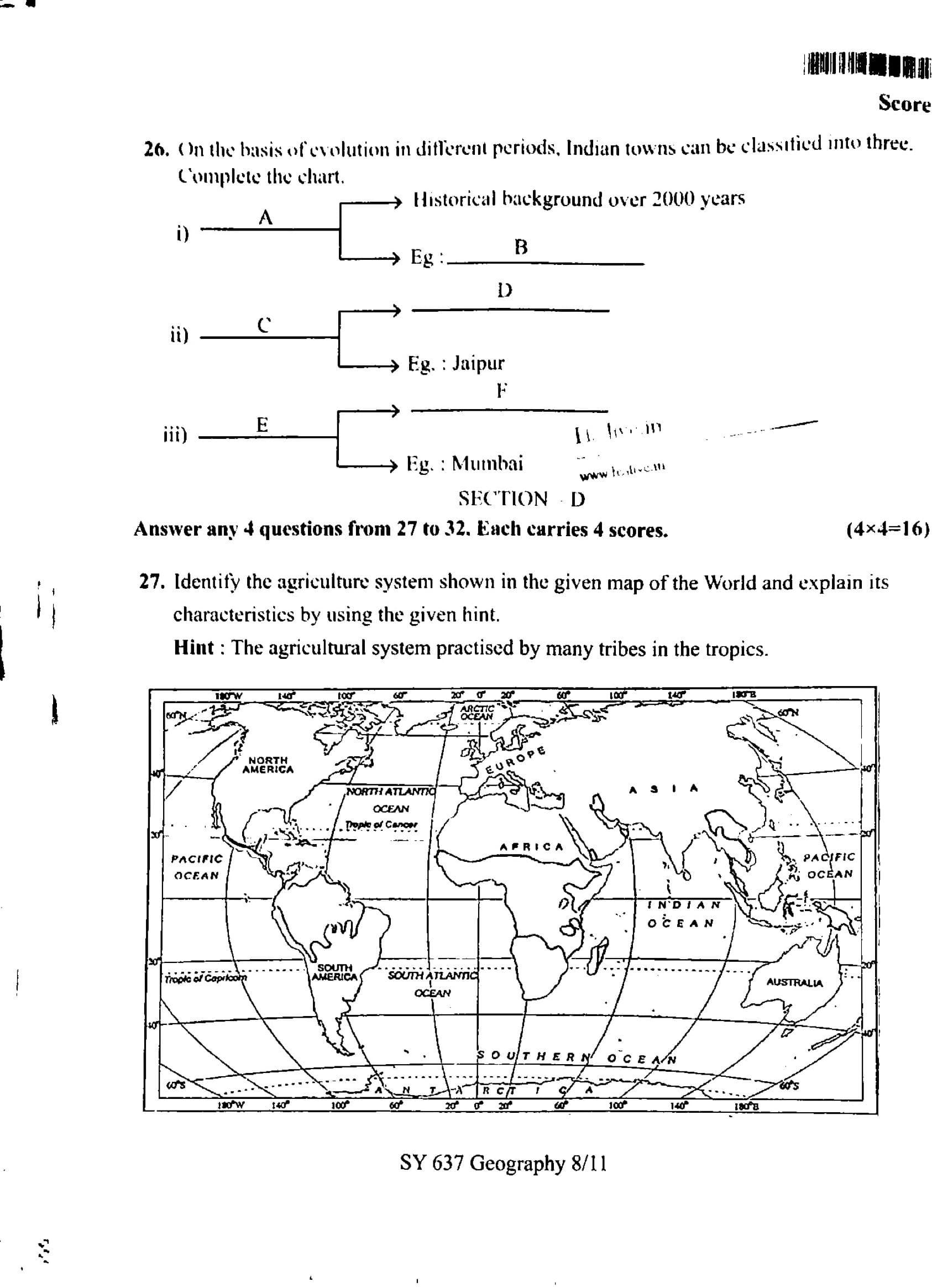
Identify the agriculture system shown in the given map of the World and explain its characteristics by using the given hint.
Hint: The agricultural system practiced by many tribes in the tropics.

View Solution
The agricultural system shown in the given map of the world is Shifting Cultivation (also known as Swidden or Slash-and-Burn agriculture). This is a form of agriculture commonly practiced by indigenous tribes in the tropical regions of Africa, Asia, and Central and South America. The main characteristics of this system are:
Step 1: Nature of Shifting Cultivation.
In shifting cultivation, small patches of forests are cleared by cutting down trees and burning the vegetation. The ash from the burnt vegetation is used as fertilizer to enrich the soil temporarily. Crops such as rice, millet, maize, and cassava are then planted in the cleared land.
Step 2: Land Rotation.
After a few years of cultivation, the soil becomes less fertile, and the farmers abandon the land and move to a new plot of land to repeat the process. The abandoned land is left to regenerate naturally. This system involves rotating land use to prevent over-exploitation of soil.
Step 3: Characteristics of Shifting Cultivation.
- Temporary Fertility: The soil is only fertile for a short period after clearing and burning.
- Low Input: This system requires minimal external inputs like fertilizers or machinery. It is labor-intensive and low-cost.
- Environmental Impact: Though it has a minimal carbon footprint initially, large-scale deforestation can contribute to environmental degradation if practiced unsustainably.
Step 4: Conclusion.
Shifting cultivation is an age-old practice that sustains many tribal communities in tropical regions. However, with increasing population pressure and land scarcity, this practice has been increasingly replaced by more permanent forms of agriculture.
Quick Tip: Shifting cultivation can be environmentally sustainable if practiced on a small scale, but large-scale deforestation for agriculture poses significant ecological risks.
Explain the geographical factors influencing the population distribution.
View Solution
Population distribution refers to the pattern of where people live in a particular area. Several geographical factors influence how and where populations are distributed across the earth. These factors can be broadly categorized into physical, environmental, and human factors.
Step 1: Physical and Environmental Factors.
- Climate: Climate plays a significant role in population distribution. Regions with moderate, temperate climates are more likely to have higher population densities, as they provide better living conditions. Harsh climates, such as deserts or polar regions, tend to have sparse populations. For example, the fertile plains and mild climate of Europe and parts of North America have led to high population densities.
- Topography: The physical features of the land, such as mountains, plains, and valleys, influence where people settle. People tend to live in flat plains and valleys where agriculture can thrive, while mountainous regions may have lower population densities due to difficulty in farming and construction.
- Water Bodies: Proximity to rivers, lakes, and coastlines has historically been an important factor for settlements, as water bodies provide resources for drinking, transportation, and trade. Coastal areas, for instance, tend to have higher populations due to their accessibility for trade and fishing.
- Natural Resources: The availability of natural resources such as fertile land, minerals, and forests can influence the population distribution. Areas rich in natural resources tend to attract larger populations because of the economic opportunities they provide.
Step 2: Human Factors.
- Economic Activities: Regions with economic opportunities such as industries, agriculture, and trade centers tend to have higher population densities. Urbanization, especially in areas with thriving economies, leads to the growth of cities. For instance, the industrial revolution in Europe led to significant urbanization and population concentration in cities.
- Political and Social Factors: Government policies, the availability of healthcare, education, and social services, as well as safety and security, can also affect population distribution. Areas with better infrastructure and social services tend to attract more people. Migration due to political unrest, wars, or social factors also influences population distribution. Quick Tip: Population distribution is heavily influenced by both physical factors like climate and topography, and human factors such as economic opportunities and social conditions.
Analyse the advantages of water transport.
View Solution
Water transport, or maritime transport, refers to the movement of goods and people via waterways such as oceans, rivers, and canals. It has been one of the oldest and most important methods of transport and continues to have several advantages over other forms of transportation.
Step 1: Cost-Effectiveness.
One of the primary advantages of water transport is its cost-effectiveness. Transporting goods by sea or river is much cheaper than air or road transport. This is particularly true for bulk goods such as raw materials (e.g., coal, iron ore) and petroleum products. Large cargo ships can carry massive quantities of goods at a low cost per unit, making water transport economically viable for international trade.
Step 2: Capacity and Efficiency.
Water transport can carry much larger volumes of goods compared to other forms of transport. Large ships, for example, can carry thousands of tons of goods over long distances without the need for frequent stops. This makes water transport ideal for transporting bulk items such as agricultural products, minerals, and heavy machinery.
Step 3: Energy Efficiency and Environmentally Friendly.
Water transport is more energy-efficient compared to road and air transport. Ships consume less fuel per ton of cargo transported over long distances, making it an environmentally friendlier mode of transport. This efficiency is critical for reducing the environmental impact of transporting goods, especially in the context of global efforts to combat climate change.
Step 4: Global Connectivity.
Water transport connects continents, countries, and regions, facilitating international trade. Shipping lanes and ports form the backbone of the global supply chain. This form of transport allows countries to exchange goods that may not be available locally, promoting economic growth and cultural exchange. Ports in major cities such as Singapore, Rotterdam, and New York serve as global hubs for trade.
Step 5: Safety.
Water transport is generally considered safe. Although natural hazards like storms and rough seas can pose challenges, the overall safety record of maritime transport is high, particularly in comparison to road and air transport. Modern technology and navigation systems have also significantly reduced the risks associated with water transport. Quick Tip: Water transport is the most economical and efficient mode for transporting bulk goods over long distances, with lower environmental impacts compared to other forms of transport.
Describe the four distinct phases of population growth in India.
View Solution
India's population growth has experienced four distinct phases. These phases are characterized by different rates of population growth, primarily influenced by changes in birth rates, death rates, and government policies. The four phases are:
1. Phase I: Slow Growth (Before 1901)
Before 1901, India’s population growth was slow due to high birth rates coupled with high death rates. The high mortality rate was caused by factors such as famine, diseases, and poor living conditions. Population growth was relatively stable, with fluctuations due to periodic famines and epidemics.
- Birth Rate: High
- Death Rate: High
- Population Growth: Slow
2. Phase II: Rapid Growth (1901–1951)
This phase marked the beginning of rapid population growth. The death rate started to decline due to improvements in public health, sanitation, and medicine. However, birth rates remained high, leading to a significant increase in population. This period was also characterized by better medical care and the introduction of vaccines to control infectious diseases.
- Birth Rate: High
- Death Rate: Declining
- Population Growth: Rapid
3. Phase III: Population Explosion (1951–1981)
The third phase saw a population explosion due to continued high birth rates and a steady decline in death rates. This phase witnessed significant advances in agriculture (Green Revolution), medical science, and sanitation, which further contributed to the population surge. However, family planning efforts were still in their infancy, and the country had no control over the high population growth.
- Birth Rate: High
- Death Rate: Low
- Population Growth: Very Rapid
4. Phase IV: Stabilisation (1981–Present)
In the current phase, population growth is beginning to stabilise as birth rates gradually decline. There is greater awareness of family planning, and government policies have focused on promoting smaller family sizes. Improved standards of living, education, and economic development have also contributed to a reduction in birth rates, while death rates remain low due to continued advances in healthcare.
- Birth Rate: Declining
- Death Rate: Low
- Population Growth: Slowing down
Conclusion:
In summary, India’s population growth has evolved from slow growth to rapid expansion, followed by a phase of stabilization as birth rates decline and death rates remain low. The country is now focusing on policies to maintain sustainable population growth. Quick Tip: India's population growth has moved through four phases: slow growth, rapid growth, population explosion, and now stabilisation as birth rates decline.
Classify and explain manufacturing industries based on the raw materials used.
View Solution
Manufacturing industries can be classified based on the type of raw materials used in the production process. The two primary classifications are:
1. Based on Raw Material Usage:
a) Agro-based Industries:
Agro-based industries use agricultural products as raw materials for manufacturing. These industries primarily involve processing raw materials derived from agriculture, forestry, and fisheries. Agro-based industries play a key role in the rural economy and contribute to food production, packaging, and other products.
- Examples: Cotton textile industry, sugar industry, vegetable oil industry, paper and pulp industry.
- Raw Materials: Cotton, sugarcane, vegetables, fruits, etc.
b) Mineral-based Industries:
Mineral-based industries rely on minerals and ores as their raw materials. These industries are vital for the production of materials like steel, cement, and glass. India has abundant mineral resources, and these industries are central to the country’s industrial growth.
- Examples: Iron and steel industry, cement industry, glass industry, aluminum industry.
- Raw Materials: Iron ore, limestone, bauxite, coal, etc.
c) Forest-based Industries:
Forest-based industries use wood, timber, and other forest products as raw materials for manufacturing. These industries include furniture making, paper production, and the creation of other wood-based products. The availability of forests and forest products plays a major role in the success of these industries.
- Examples: Paper industry, furniture manufacturing, plywood industry.
- Raw Materials: Timber, wood, bamboo, resin, etc.
d) Marine-based Industries:
Marine-based industries use products from the sea as their raw materials. This includes industries involved in seafood processing, fish farming, and the production of marine-based products like salt and fishmeal.
- Examples: Fish processing, seafood export, salt production, seaweed industries.
- Raw Materials: Fish, seafood, seaweed, salt.
Conclusion:
Manufacturing industries can be broadly classified into agro-based, mineral-based, forest-based, and marine-based industries based on the raw materials they use. These industries contribute significantly to the economy by producing a wide range of products from natural resources. Quick Tip: Manufacturing industries are classified based on raw materials, such as agricultural products, minerals, forest resources, and marine products, each contributing to different sectors of the economy.
Identify and mark the following geo information on the given outline map of India.
a) The least densely populated state according to the 2011 census.
b) A mining town in Assam.
c) The leading producing state of bauxite.
d) Largest container port of India.
View Solution
a) The least densely populated state according to the 2011 census.
According to the 2011 Census of India, the state with the lowest population density is Arunachal Pradesh. The population density of Arunachal Pradesh is very low compared to other states, mainly because of its hilly terrain, sparse settlement pattern, and vast forested areas. The state's location in the northeastern part of India, with borders shared with China, Bhutan, and Myanmar, also contributes to its relatively low population density. You can mark Arunachal Pradesh on the map of India in the northeastern region, which is bordered by Assam to the south and Nagaland to the southeast.
b) A mining town in Assam.
A notable mining town in Assam is Margherita, which is located in the Tinsukia district of eastern Assam. Margherita is famous for its coal mines, and it has historically been one of the major coal mining areas in India. The town is also known for its scenic beauty and is situated near the Indo-Burma border. Mark Margherita on the map in the northeastern part of Assam, near the Assam-Nagaland border. Margherita has played an important role in the local economy due to its coal production, which supplies energy resources to various regions of India.
c) The leading producing state of bauxite.
The state of Odisha is the leading producer of bauxite in India. Bauxite is the primary ore of aluminum, and Odisha has large reserves of it. The state is home to the Koraput and Kalahandi districts, which are the major bauxite-producing regions in India. Odisha accounts for a significant portion of India's bauxite production, which is essential for the aluminum industry. You can mark Odisha on the map of India on the eastern coast, bordered by West Bengal to the north, Jharkhand to the west, Chhattisgarh to the southwest, and Andhra Pradesh to the south. Odisha's vast deposits of bauxite and other minerals make it a key player in India’s mining industry.
d) Largest container port of India.
The Jawaharlal Nehru Port (JNPT) in Mumbai is India's largest container port. It is located in the Mumbai Metropolitan Region on the west coast of India. JNPT is also one of the busiest ports in India in terms of container traffic and plays a crucial role in India's international trade. This deep-sea port has the infrastructure to handle large container ships and is key for the import and export activities in the country. You can mark Mumbai on the western coast of India on the map, specifically highlighting the area around the JNPT near Navi Mumbai, which is a vital part of the country's maritime infrastructure. The port's strategic location on the Arabian Sea makes it a critical hub for global shipping routes.
These key geographic locations are vital to understanding India's industrial, economic, and resource-related landscape. Marking these places on a map will help in visualizing their importance to the country’s economic and regional development. Quick Tip: Arunachal Pradesh has the least population density in India, Margherita is an important coal mining town, Odisha is the leading bauxite producer, and Mumbai is home to the largest container port, JNPT, in India.


Comments